


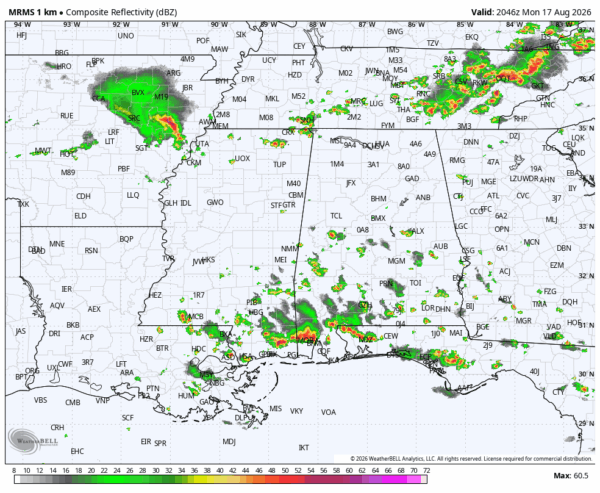
RADAR CHECK: We have scattered thunderstorms over the southern 2/3 of Alabama this afternoon… the northern third of the state is mostly rain-free. One heavy storm is moving into Mobile at mid-afternoon with heavy rain and strong, gusty winds. Away from the thunderstorms most places are in the 95-100 degree range at mid-afternoon.
We also note strong storms over Tennessee… some of those could dip into North Alabama this evening with potential for gusty winds and heavy rain in spots.
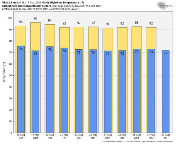
REST OF THE WEEK: Heat levels slowly come down, and by Friday highs will be in the low 90s for much of the state. Afternoon showers and storms are always possible on any August day, but they remain random and scattered… mostly between noon and 9:00 p.m.
The weekend will feature classic summer weather… partly sunny days, highs in the low 90s, and a handful of showers and storms around during the afternoon and evening hours.
No real change next week… See the video briefing for maps, graphics, and more details.
TROPICS: The Atlantic basin is unusually calm for mid-August, and tropical storm formation is not expected for at least the next seven days.
ON THIS DATE IN 1969: One of the most powerful hurricanes in American history made landfall on the Mississippi coast near Waveland. Hurricane Camille is one of only four Category 5 hurricanes ever to make landfall in the continental United States. The actual maximum sustained winds of Hurricane Camille are not known as the hurricane destroyed all the wind-recording instruments in the landfall area. Re-analysis data found peak winds of 150 knots (roughly 175 mph) along the coast. A devastating storm surge of 24.6 feet occurred at Pass Christian, MS. A total of 259 people lost their lives, including 172 people in Mississippi. This made Camille one of the deadliest hurricanes in U.S. history.
Look for the next video briefing here by 6:00 a.m. tomorrow…



