


RADAR CHECK: Scattered strong thunderstorms are moving across the southern half of Alabama this afternoon… some producing strong wind gusts, heavy rain, and very frequent lightning. A severe thunderstorm watch is in effect for the southwest counties of the state until 7p CT.
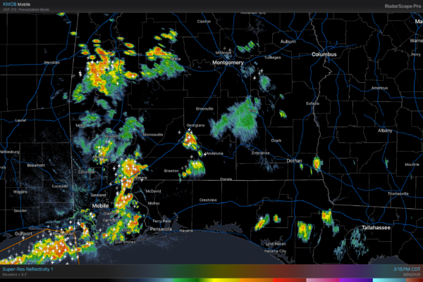
Drier air remains over the northern half of the state, where the weather is rain-free this afternoon. Scattered storms over South Alabama end after sunset.
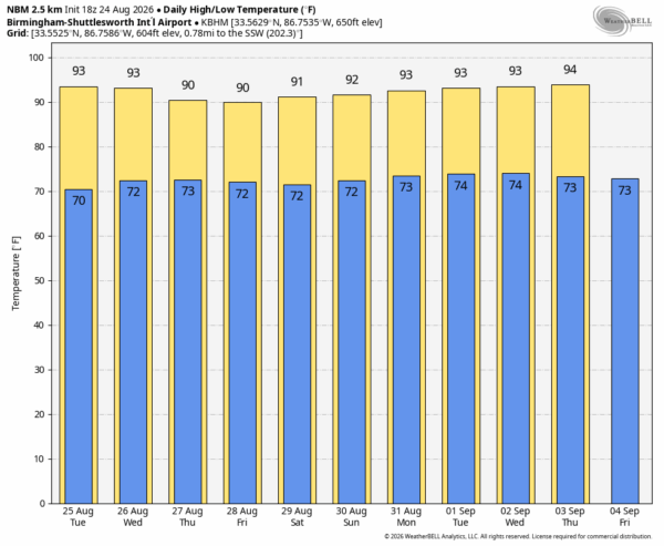
REST OF THE WEEK: The weather won’t change much tomorrow with the highest risk of a shower or storm over the southern half of the state. Moisture moves northward Wednesday, and scattered showers/thunderstorms are likely statewide over the latter half of the week. Most of them will come from noon to midnight, and afternoon highs will be close to 90 degrees.
THE WEEKEND: An upper ridge begins to build across the Deep South, which should mean fewer showers for the weekend along with slightly higher heat levels. Highs will be in the low to mid 90s Saturday and Sunday.
The ridge will likely hold into at least the first half of next week, meaning meteorological fall will begin with highs in the 90-95 degree range for most of Alabama, which is not unusual for early September. See the video briefing for maps, graphics, and more details.
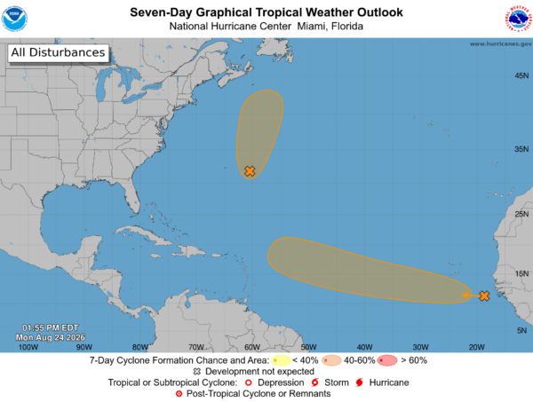
TROPICS: NHC is monitoring two areas of interest in the Atlantic. One is east of Bermuda; this will move north on a track well east of the U.S.; chance of development is 50 percent.
The other one to watch is a tropical wave moving off the coast of Africa today. Chance of development is 60 percent… if anything develops, it will most likely turn north into the open Atlantic well east of the U.S.
No tropical storms or hurricanes are expected in the Gulf for at least the next 10-15 days.
ON THIS DATE IN 1992: Hurricane Andrew made landfall on the South Florida coast near Homestead. It was the most destructive hurricane to ever hit Florida in terms of structures damaged or destroyed, and was the strongest hurricane to make landfall in the United States in decades. It was also the costliest hurricane to strike anywhere in the country, until it was surpassed by Hurricane Katrina in 2005.
Andrew is one of only four tropical cyclones to make landfall in the continental United States as a Category 5, alongside the 1935 Labor Day hurricane, Hurricane Camille in 1969, and Michael in 2018. While the storm also caused major damage in The Bahamas and Louisiana, the greatest impact was felt in South Florida, where the storm made landfall as a Category 5 hurricane, with 1-minute sustained wind speeds as high as 165 mph and gusts as high as 177 mph.
Look for the next video briefing here by 6:00 a.m. tomorrow…



