


A FEW STORMS LATER TODAY: Like yesterday, the best chance of scattered showers/storms across Alabama this afternoon will be over the southern third of the state, where SPC maintains a “marginal risk” (level 1/5) of severe thunderstorms.
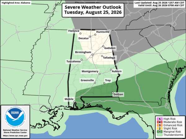
Heavier storms this afternoon will produce strong wind gusts, heavy rain, and frequent lightning. Dry air remains over the northern half of Alabama and most communities there will stay dry. Today’s high will be in the 90-95 degree range.
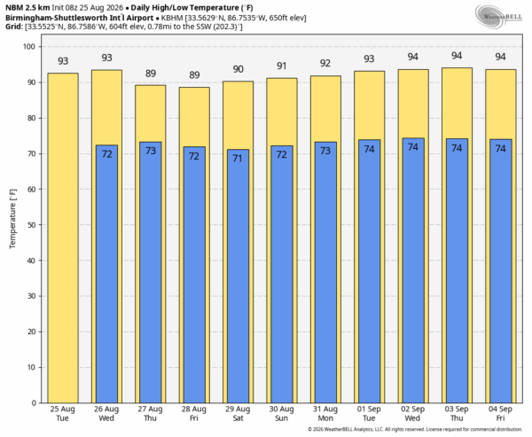
Scattered, mostly afternoon and evening showers and thunderstorm are likely statewide tomorrow through Friday as moisture moves northward. Most of the showers will come from noon to midnight, and highs will drop into the 88-92 degree range.
THE WEEKEND: Showers become fewer in number as an upper ridge begins to rebuild across the Deep South. Heat levels creep up again with afternoon highs back in the low to mid 90s.
The ridge stays in place through next week. We all know it doesn’t magically turn cooler when September arrives in Alabama… highs will be in the mid 90s for much of the week with only isolated afternoon showers/thunderstorms. See the video briefing for maps, graphics, and more details.
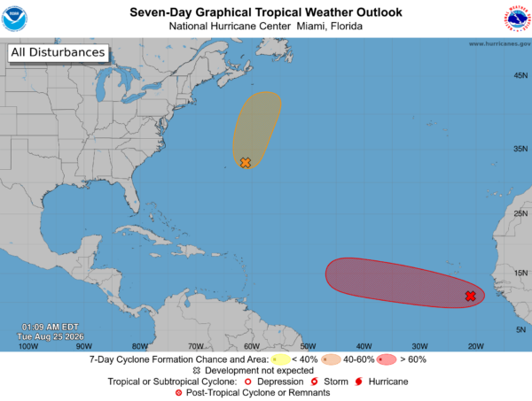
TROPICS: NHC continues to monitor two tropical waves. One is east of Bermuda (Invest 95L); it has a 40 percent chance of development as it moves northward far from land. This system could still become a short-lived tropical depression or storm later today before encountering increasingly hostile conditions tonight and Wednesday, likely ending its chances for development.
The other is an area of low pressure (Invest 96L) centered a few hundred miles south-southeast of the Cabo Verde Islands. It is producing disorganized showers and thunderstorms… environmental conditions appear conducive for gradual development, and this system is likely to become a tropical depression during the next few days while it moves westward to west-northwestward across the eastern and central tropical Atlantic. Environmental conditions could become less conducive for development by the weekend.
Chance of development is 70 percent, but if development does happen most global models show the system dissipating this weekend far from land.
No tropical storms or hurricanes are expected across the Gulf for at least the next 10-15 days.
ON THIS DATE IN 2005: Katrina made its first U.S. landfall in South Florida during the evening of August 25, near the Miami-Dade/Broward County line. It was a Category one hurricane, with maximum sustained winds near 80 mph. It crossed South Florida and emerged into the Gulf, where it reached category five strength. It would make the next landfall as a Category 3 hurricane August 29 near the town of Buras in southeast Louisiana. The final landfall came near the mouth of the Pearl River on the Louisiana-Mississippi border.
Look for the next video briefing here by 3:00 this afternoon… enjoy the day!



