


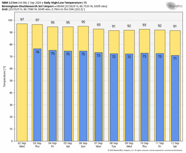
SEPTEMBER HEAT: A strong upper high will remain parked over the region, meaning above average temperatures through the Labor Day weekend. Afternoon highs will remain generally in the mid to upper 90s, with daily heat index values over 100. Each afternoon a few showers and storms will pop up, but they will be very isolated, and mainly over the southern half of the state.
Heat levels will be slight lower next week, but still elevated with afternoon highs mostly in the low 90s.
We should not it is not unusual for Alabama to have hot days in early September. We are not close to record September heat.. 1925 led the way. The sheer peak intensity of the September 1925 heatwave has never been replicated in Alabama.
*Alabama’s statewide average high for September 1925 was about 96.8°F, making it the hottest September on record.
*Birmingham recorded 14 days at or above 100°F that September, still the record.
*Birmingham reached 106°F on September 5 and 6, the city’s September record.
*Hottest temperature on record in Alabama is 112 degrees, recorded on September 5, 1925 in Centreville.
See the video briefing for maps, graphics, and more details.
FOOTBALL WEATHER: We are projecting temperatures in the 96-99 degree range in Tuscaloosa Saturday by the fourth quarter of the Bama/ECU game at Bryant-Denny Stadium (kickoff at 11a CT). The heat index could be as high as 110.
Jacksonville State, South Alabama, Troy, Alabama State, and Alabama A&M all have Saturday home games, but they are all evening games with temperatures falling through the 80s.
Auburn plays in Mercedes-Benz Stadium Saturday against Baylor (2:30p CT kickoff).. it will be a pleasant 72 degrees in the climate controlled dome.
UAB will take on Illinois in Champaign tomorrow night (8p CT kickoff)… the sky will be clear with temperatures falling the low 80s at kickoff into the upper 70s by the second half.
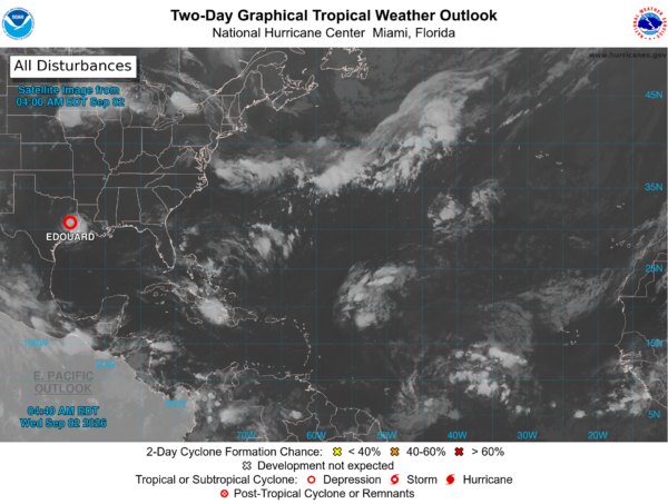
TROPICS: Edouard is inland over Southeast Texas and will dissipate later today; the Atlantic basin is unusually calm for early September and tropical storm formation is not expected through the next seven days.
ON THIS DATE IN 1935: One of the most powerful hurricanes in U.S. history slammed into the Florida Keys. The compact Category 5 storm had an estimated maximum sustained wind of 185 mph and a central pressure of 892 millibars—still the lowest pressure ever recorded at a U.S. hurricane landfall.
The hurricane caused catastrophic damage in the upper Florida Keys, as a storm surge of approximately 18 to 20 feet (5.5 to 6.1 m) swept over the low-lying islands. The hurricane’s strong winds and the surge destroyed nearly all the structures between Tavernier and Marathon. The town of Islamorada was obliterated. Portions of the Key West Extension of the Florida East Coast Railway were severely damaged or destroyed. In addition, many veterans died in work camps created for the construction of the Overseas Highway, in part due to poor working conditions. The hurricane also caused more damage in northwest Florida, Georgia, and the Carolinas.
Look for the next video briefing here by 4:00 this afternoon… enjoy the day!



