Daily Weather Briefing
Saturday, September 19, 2026
ALABAMA THIS MORNING
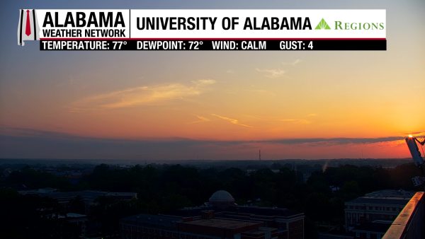
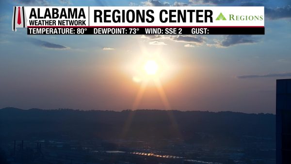
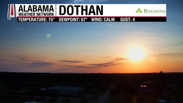
It’s a wonderful Saturday morning with temperatures in the upper 60s in the northern half of the state and lower 70s in the southern half! Skies are mostly clear, with just a few clouds, and our Regions Skycams in Tuscaloosa, Birmingham, and Dothan give us front-row seats to the beautiful sunrise.
ALABAMA 7 DAY FORECAST
The weather over the next week will be slightly rainier than it has been recently, and although this weekend and early next week will be hot, we’ll start to see a cooling trend toward the end of next week. Higher rain chances this weekend are due to an upper-low in the Gulf increasing moisture and the upper-level ridge moving westward some. The “cooldown” next week is thanks to an upper-level trough that will dig into the Southeast.
HEAT CONTINUES TODAY, SCATTERED SHOWERS POSSIBLE – Sept 19
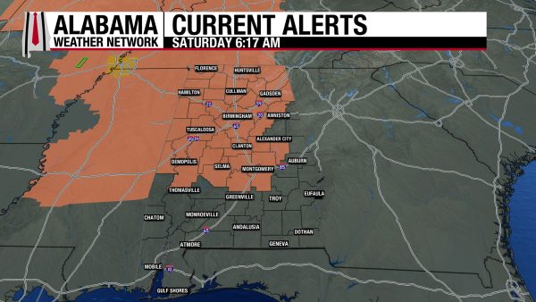
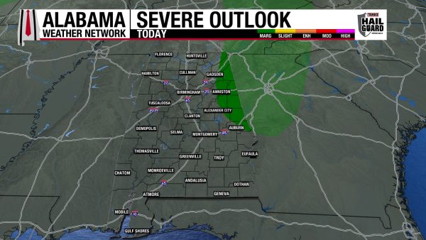
Before we can get to those cooler temperatures, we have to endure a few more days of hot weather. Today, highs will climb into the mid 90s south and the upper 90s to 100 degrees in the northern two-thirds of the state. The 100-degree temperatures will favor the western portion of this area. Feels-like temperatures across most of the northern two-thirds of Alabama will rise into the 105–109-degree range, and a Heat Advisory is in effect through 8 p.m. for the region. Rain chances are higher than they’ve been recently, reaching 30% statewide. Afternoon and evening scattered showers and thunderstorms are possible, with the easternmost portions of north and central Alabama under a Marginal Risk (1/5) of Severe Thunderstorms. Any storms that form today could bring strong winds, lightning, and heavy downpours, but the outlooked region could see severe storms that pack more of a punch. This will be something to watch as many college football games are being played today.
HOT AND DRIER TO START THE WEEK – Sept 20-21
Sunday and Monday will return to the slightly lower rain chance of 20%, with isolated to scattered thunderstorms possible each day.
Sunday’s highs will range from the low to mid 90s south to the mid to upper 90s north, and any storms that develop are not expected to become severe.
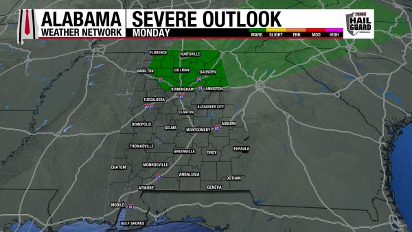
A similar temperature spread is anticipated on Monday, but storms in the north will have a Marginal (1/5) chance of becoming severe and producing damaging winds, frequent lightning, and heavy rain. Storms could form anywhere across the state in the afternoon and into the evening.
“COOLDOWN” BEGINS TUESDAY – Sept 22-25
As we head into the thick of the week, highs will slowly decrease each day. Rain chances will slowly fall as well.
On Tuesday, highs will reach the low 90s to mid 90s and there will be a 20% chance of afternoon showers and thunderstorms.
Wednesday’s highs will be lower, ranging from the upper 80s to low 90s across the northern half of the state and the low 90s over the southern half. Isolated to scattered showers and thunderstorms will have a 20% chance of development in the afternoon and evening.
Thursday and Friday will be cause for excitement for fall weather fans. Thursday’s highs will be in the mid to upper 80s in the north and the mid 80s across the rest of the state. Rain chances drop to only 10% over Alabama.
Then Friday’s highs will again spread from the mid to upper 80s statewide, and rain chances will diminish. Although these temperatures aren’t cold, they will feel pleasant compared to the 90-degree heat we’ve endured this September.
RAINFALL OUTLOOK
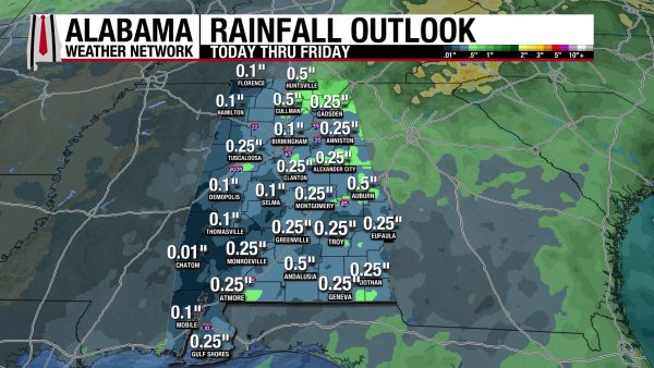
Rainfall amounts over the next week are still not very high, with averages ranging from a tenth of an inch to half an inch of rain. Under isolated thunderstorms, locally higher amounts are possible.
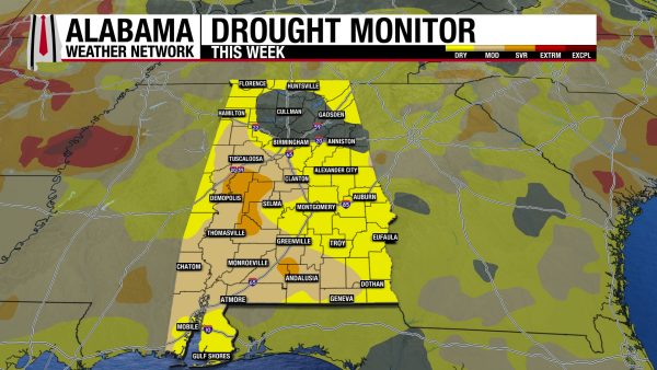
DRY CONDITIONS LEADING TO WORSENING DROUGHT
Alabama’s drought has spread further across the state over the past week, with only 15.55% of the state’s drought-free now. Abnormally Dry (D0) conditions have expanded to cover 46.88% to 48.63% of the state. Moderate Drought (D1) conditions have expanded to cover 31.12% of the state from 26.60% last week. Severe Drought (D2) conditions have expanded as well, as they now stretch across 4.71% of Alabama. With another dry week on the way, these drought conditions will be exacerbated.
FOOTBALL FORECAST
Alabama will host Florida State this afternoon at 2:30 p.m. CDT at Bryant-Denny Stadium. It will be another very hot September day in Tuscaloosa. Temperatures will be in the mid to upper 90s during most of the game. A few isolated showers are possible across West Alabama; hopefully one gets close enough to cool things down a bit. But that is not especially likely.
Auburn hosts Florida this evening at 6:00 p.m. CDT at Jordan-Hare Stadium. Temperatures will fall from around 90 at kickoff into the upper 70s by the final whistle. There is a chance of a passing shower or thunderstorm, mainly during the first half of the game. Another lightning delay is not out of the question.
Very similar weather for the Jacksonville State home game this evening against Georgia Southern; a passing shower or storm is possible during the first half.
North Alabama plays its first game in the new Bank Independent Stadium/Bobby Wallace Field this evening against Alcorn State at 6:00 p.m. CDT. Expect low 90s at kickoff, upper 70s by the final whistle. The chance of a shower is very low.
Expect similar weather conditions for home games this evening at South Alabama in Mobile and West Alabama in Livingston.
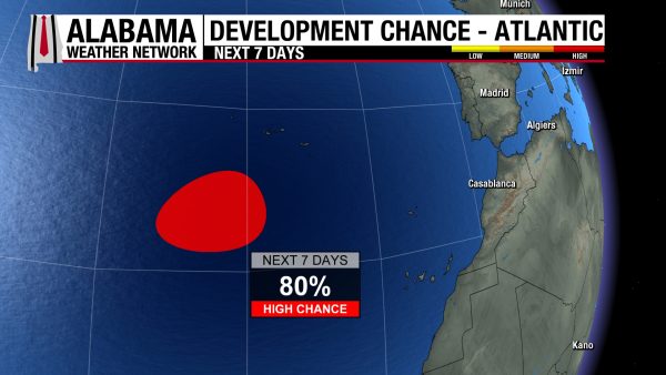
THE ATLANTIC
The disturbance, labeled AL99, has an 80% chance of development over the next seven days. It is expected to stay southwest of the Azores for the next couple of days but could make a southwestward turn later this week.
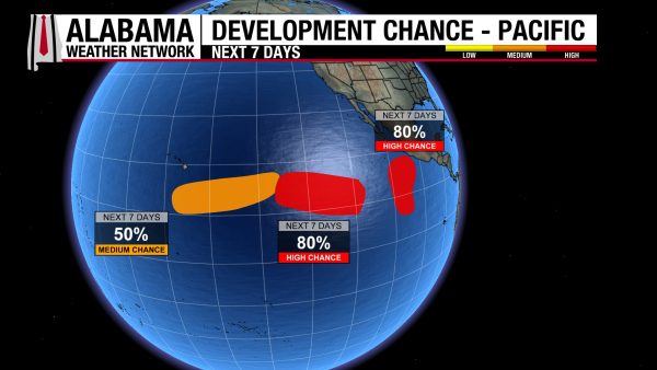
THE PACIFIC
The Pacific still hosts three disturbances that have a 50% chance, 80% chance, and 80% chance (from left to right on the graphic) of development into a tropical system over the next week.
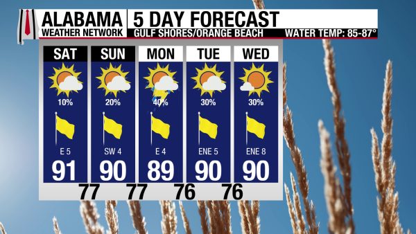
ENJOYABLE BEACH WEEKEND AHEAD
Today and tomorrow will be quite pleasant for beachgoers, as highs will be in the low 90s. There will be a light breeze (out of the east today and southwest tomorrow), and sunny skies! Rain chances are low as well, only at 10% today and 20% tomorrow. The rip current risk is Low, and the surf height is 1 to 2 feet. Besides rain chances increasing to 30-40%, conditions will be pleasant next week as well.

TODAY IN WEATHER HISTORY
September 19, 2009 – The Epic Georgia Floods
Heavy rain began plaguing Georgia in mid-September 2009 after a surface low moved out of the Gulf of Mexico and into Louisiana. Rain began falling across Georgia on September 14, and the pattern persisted for days. By September 19, the low to the west was weakening and moving northeast, but abundant Gulf moisture continued streaming into the region. At the same time, high pressure along the East Coast began feeding additional Atlantic moisture into Georgia from the southeast.
Rainfall intensified on September 19. Atlanta’s Hartsfield-Jackson International Airport measured 3.70 inches between sunrise and 8 p.m., establishing a daily rainfall record, while some parts of the metropolitan area received more than five inches. The next day brought another round of heavy rain, with more than three inches falling across many locations. Douglas County reported an extraordinary 11.80 inches.
The rain still was not finished. On September 21, western portions of the Atlanta metropolitan area were hit especially hard, with widespread totals of 9 to 12 inches. The tremendous runoff sent creeks and rivers rapidly out of their banks. Sweetwater Creek reached its highest level on record, while flooding of historic proportions spread across the region.
Major transportation routes disappeared beneath the water. Sections of Interstate 20 and Interstate 285 were closed, while Interstate 575 was blocked in Cherokee County. Homes and businesses flooded, and rides at Six Flags Over Georgia stood in deep water. More than 20,000 structures were damaged during the disaster, with losses approaching $300 million.
The flooding ultimately claimed ten lives, most involving people who drove into flooded areas. The event became one of Georgia’s most significant modern flood disasters and demonstrated how several days of persistent moisture can transform ordinary rainfall into a life-threatening emergency. Ten people died, underscoring how quickly extreme rainfall can become deadly flooding.

IMAGE OF THE DAY
Skywatcher Daniel Harbin sent in a photo of the colorful sunrise in Trenton this morning!