Daily Weather Briefing
Saturday, October 10, 2026

ISAIAS’ IMPACTS TODAY -Oct 10
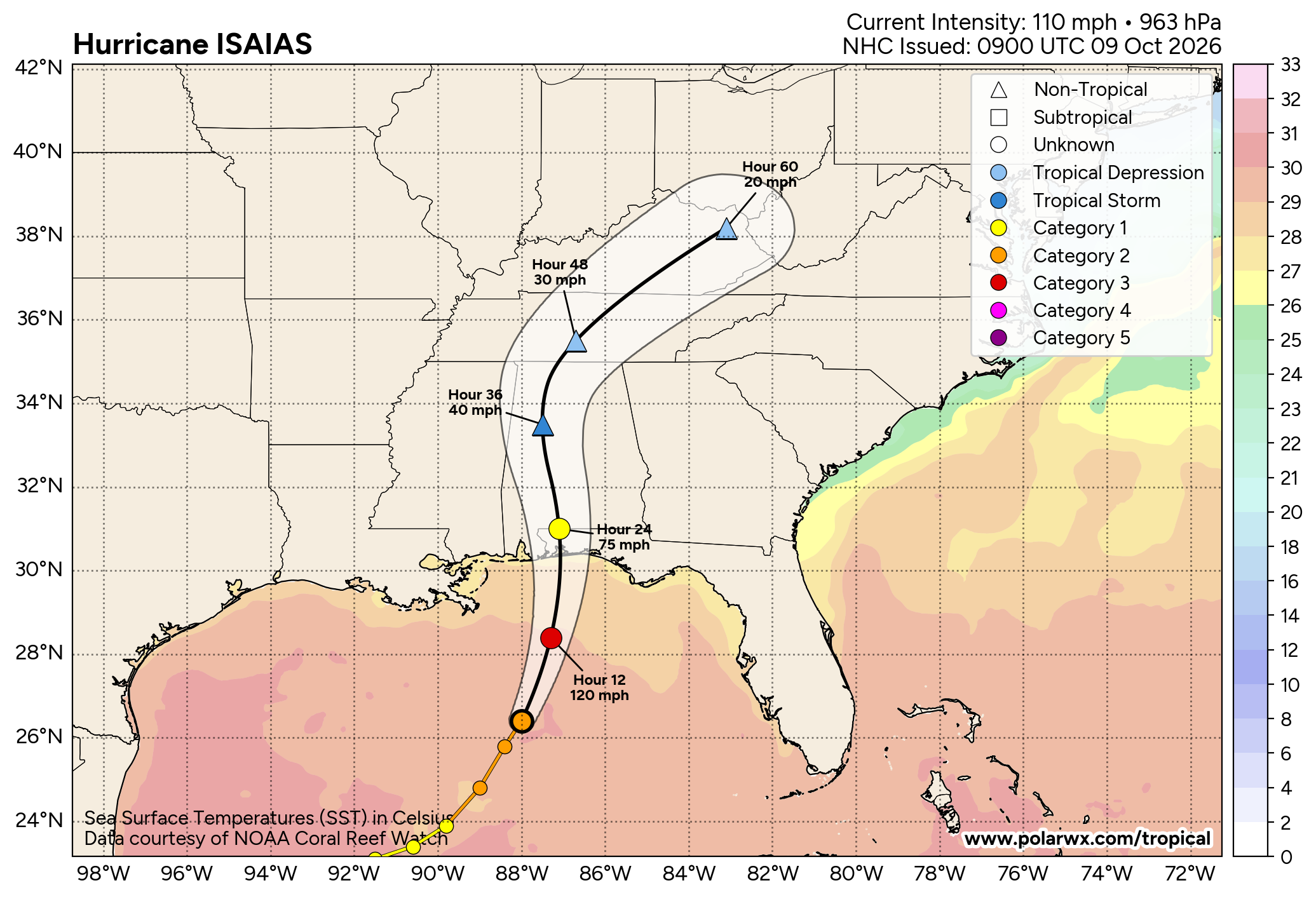
Hurricane Isaias made landfall near Destin, Florida, last night at 8:30 p.m. as a Category 2 Hurricane. It is now a Post-Tropical Cyclone with its rain bands impacting the northern half of the state and much of Georgia this morning. Power outages statewide have reached 319,000 as of about 6 a.m. this morning. As we head into the day today, south Alabama will be mostly dry, with just a shower or two possible. The northern half of the state will continue to see wind and rain throughout the day today, picking up an additional 2 to 4 inches. Highs will be in the mid to upper 60s to the low 70s statewide. These strong winds and heavy rains keep the risk of downed trees and power lines and flash flooding elevated, so although the storm has weakened, continue to stay weather-aware today.


Advisories/Warnings:
A Wind Advisory (brown) stretches across the northern two-thirds of the state until 7 p.m. tonight as those wind gusts reach up to 50 mph today. Northeast Alabama will see stronger wind gusts up to 60 mph, and a High Wind Warning (yellow) extends until 7 p.m. A Flood Watch (not shown) extends over the northern two-thirds of the state until 7 a.m. tomorrow morning. A Flood Warning (bright green) is in effect for parts of south Alabama as well until 9 a.m.
PLEASANT DAY TOMORROW – Oct 11
A few sprinkles could impact north Alabama tomorrow morning, but the weather will be pleasant. Skies will clear from south to north tomorrow, although winds may stay a little elevated between 10 and 20 mph, gusting to about 25. Highs will increase into the low to mid 70s across the northern half of the state and the low to mid 80s in the southern half.
HOT AGAIN THIS WEEK Oct 12-16
Monday through Friday will be hot and dry as an upper-level ridge builds into the Southeast. Highs on Monday will range from the low to mid 80s, Tuesday will be in the mid 80s north and upper 80s south; then Wednesday will increase to the upper 80s statewide, with the western portion of the state flirting with the 90s. By Thursday, again highs stay in the mid to upper 80s, and Friday will be less hot in the upper 70s north and low to mid 80s in the southern two-thirds of the state. Lows will be mid 50s to mid 60s each morning.
FOOTBALL FORECAST
BAMA VS. GEORGIA
Conditions look decent for the Alabama-Georgia game that is scheduled for 6:30 p.m. CDT tonight. Winds are expected to be around 10-15 mph during the game, with possible drizzle. Temperatures will be in the mid 60s. Continue to heed local officials’ advice today.

THE ATLANTIC
Isaias is now a Post-Tropical Cyclone and is forecast to move north through Alabama today, entering Tennessee by late tonight/early tomorrow morning. It will take on extra-tropical characteristics and act as a mid-latitude cyclone (storm systems with a low-pressure system and warm and cold fronts). It will bring rain and storms to Georgia and the Carolinas today and impact the Mid-Atlantic late this weekend and early next week. Since it is a post-tropical cyclone, the National Hurricane Center issued its final advisory on the storm this morning at 4 a.m. CDT.

PLEASANT WEATHER CONDITIONS RETURN, SURF STILL ROUGH
The Alabama Gulf Coast is in the clear today, with pleasant weather conditions in the forecast. The high will be in the upper 70s, the sky will be mostly sunny, and winds will still be quite breezy at 20 mph from the west. The rip current risk remains High today and tomorrow before falling later this week. Warm and sunny conditions are expected through Wednesday at least.
TODAY IN WEATHER HISTORY
October 10, 2018 – Hurricane Michael
Hurricane Michael slammed into the Florida Panhandle on October 10, 2018, making landfall near Mexico Beach shortly before 1:30 p.m. CDT. Post-storm analysis by the National Hurricane Center determined that Michael came ashore as a Category 5 hurricane with maximum sustained winds of 160 mph and a minimum central pressure of 919 millibars. At the time, only the 1935 Labor Day Hurricane and Hurricane Camille in 1969 had struck the continental United States with a lower central pressure.
Mexico Beach was ground zero. Michael’s violent winds and storm surge devastated the small coastal community, sweeping homes from their foundations and leaving entire blocks reduced to slabs and debris. Storm surge inundation reached roughly 14 feet above ground level in portions of Mexico Beach, while destructive waves rode on top of the surge. Nearby Tyndall Air Force Base also suffered catastrophic damage, with hangars, buildings, aircraft facilities, and infrastructure heavily damaged or destroyed.
Panama City and surrounding Bay County endured extreme wind damage as Michael’s compact inner core moved inland. Roofs were torn from homes and businesses, trees were snapped or uprooted, power poles were destroyed, and communications collapsed across large portions of the region. A pressure of 27.24 inches of mercury was measured at a private station in Panama City, dramatically lower than pressures observed there during previous hurricanes.
Michael weakened only gradually after landfall, carrying destructive winds far inland across northern Florida and into southwest Georgia. It remained a major hurricane as it crossed portions of the Florida Panhandle and was still a Category 3 hurricane when its center entered Georgia, making Michael the first known major hurricane to move into that state since reliable records began. Extensive damage occurred to homes, timber, pecan orchards, cotton fields, and agricultural infrastructure across southwest Georgia.
Southeastern Alabama also experienced damaging winds, heavy rain, and widespread power outages, particularly across the Wiregrass. Trees and power lines were brought down across numerous counties as Michael’s circulation passed just east of the state. Even well inland, the storm retained a level of intensity rarely experienced from a Gulf hurricane.
Michael killed dozens of people in the United States and caused roughly $25 billion in damage. Its final upgrade to Category 5 made it only the fourth Category 5 hurricane known to have made landfall in the continental United States at the time, joining the Labor Day Hurricane of 1935, Camille in 1969, and Andrew in 1992. Coming ashore at nearly peak intensity, Michael became one of the most destructive hurricanes ever to strike the Florida Panhandle.