


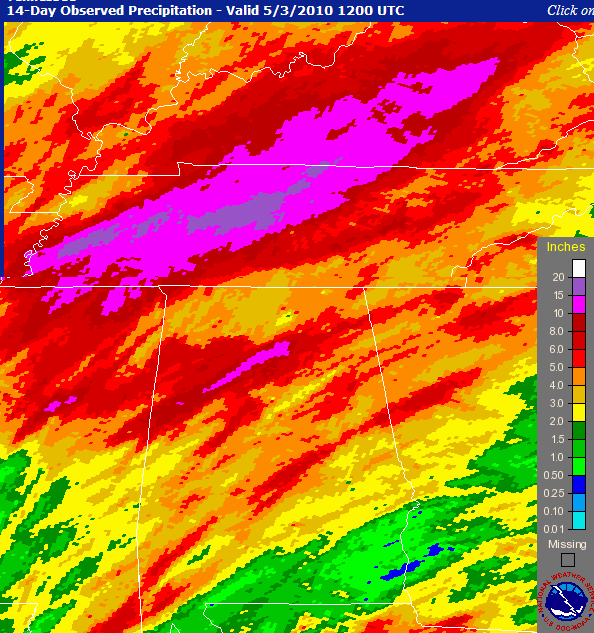
14-day rainfall (SERFC)
The above map shows the estimated rainfall over Kentucky, Tennessee, Alabama, and much of Mississippi and Georgia, over the past 2 weeks. These estimates combine radar-estimated precipitation with rain gauges to calibrate the radars.
Note the large areas of 10″ or more of rain. This includes most of western and middle TN, and part of north-central AL. Most of the rain in west TN fell late last week, and most of it near Nashville this weekend. Some locations in TN received over 15″. Blog reader Charles Nickolaus and his family in Brentwood, TN, who live in an area not really in a “flood plane”, had to move vehicles uphill, move furniture to the 2nd floor of houses, etc., to reduce flood damage.
The heaviest rain in Alabama flows into the Mulberry Fork, then toward Mobile. The rain in Tennessee flows into the Tennessee River, the Duck River and the Cumberland River.
There has also been flooding in parts of north Alabama (examples are near Huntsville and in Walker County) and in east-central Alabama, where up to 5″ of rain fell last night.
There may be some minor flooding along the Mulberry Fork today. The river is above flood stage at Cordova, and water was over Alabama Highway 69 earlier. Here is the river gauge data from Cordova.
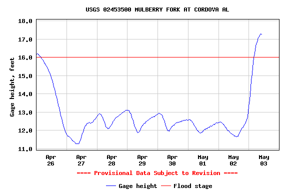
Interestingly, there was less rain this weekend in central Alabama than last weekend, but with the ground saturated, the river is more full this week.



