


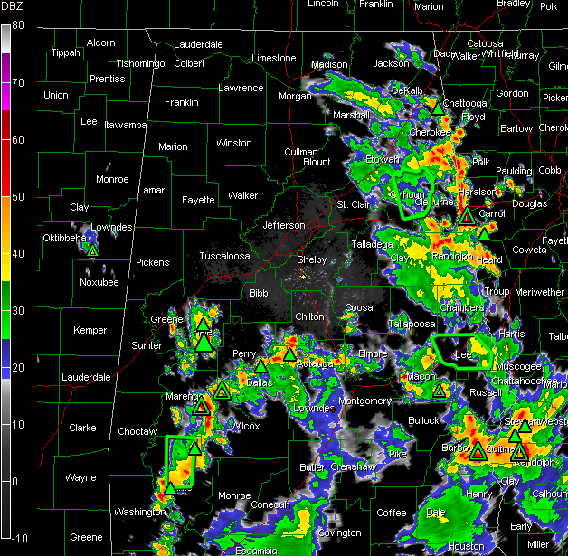
Heavy rain and storms at this hour are in the eastern border counties of Alabama from Randolph through Cleburne and into Cherokee County.
There is already a flash flood warning for Calhoun County, including Anniston, and I would not be surprised to see one required for some other counties in East Alabama. Small hail is also possible from some of the stronger storms.
Arc of thunderstorms from Wetumpka and north of Prattville to north of Selma to south of Linden to near Grove Hill in Southwest Alabama is the strongest in the state. Several indications of hail and even large hail from these storms.
Heavy storms near Billingsley in Autauga County are edging closer to Maplesville in Chilton County and generally toward Centreville.
In Coosa County…heavy showers have edged as far northward as to a point between Clanton and Rockford. I say that because that is upstream from Birmingham. They actually sprung up from an outflow boundary spit out by the East Alabama storms that will likely enhance the storms from western Chilton up into Bibb County.
There is a a cluster of storms over Hale County…it has lots of lightning and nearly certainly some hail. It is between Akron and Greensboro.
The East Alabama showers have edged back as far west as Talladega. Lake Logan Martin is getting a reprieve for now, wit the closest showers back east of Oxford.
Bottom line is…showers and storms will continue to overspread the rest of Central Alabama through the late afternoon and into the evening hours.
A severe thunderstorm watch continues until 7 p.m. CDT for most of South Central Alabama.



