FAST FACTS AS OF 1 AM. CDT…
LOCATION…26.4N 83.4W
ABOUT 395 MI…635 KM ESE OF THE MOUTH OF THE MISSISSIPPI RIVER
ABOUT 85 MI…135 KM SW OF SARASOTA FLORIDA
MAXIMUM SUSTAINED WINDS…35 MPH…55 KM/HR
PRESENT MOVEMENT…WNW OR 295 DEGREES AT 17 MPH…28 KM/HR
MINIMUM CENTRAL PRESSURE…1010 MB…29.83 INCHES
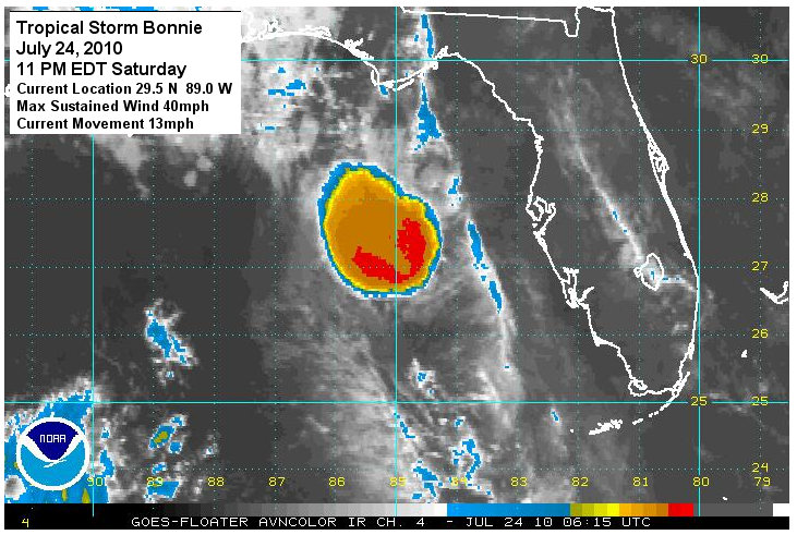
Satellite images of Tropical Depression Bonnie over the southeastern Gulf of Mexico show a tremendous burst of convection firing on the northern edge of the small center.
This could signal a strengthening trend that could bring the system back to tropical storm status this morning.
Still, for now the system is very disorganized and any intensification would likely be very slow. Plus, the system is undergoing moderate southeasterly wind shear, which also will limit its development.
AF Reserve Recon mission 6 is en route back to Keesler AFB in Biloxi. It will pass mission 7 which has just taken off the in the past hour or so from Keesler, on its way to the storm.
Bonnie should make landfall near New Orleans late Saturday night or early Sunday morning, likely around midnight. Tropical storm force winds will brush the Alabama coast around Fort Morgan around dark Saturday night and affect the entire Mississippi Coast a couple of hours later. Tropical storm force winds should reach the Greater New Orleans area around 10 p.m. CDT Saturday evening.
Three to four inch rainfall amounts will affect SE Louisiana, with lesser amounts the further you go inland into Alabama and southern Mississippi.
We will have frequent updates throughout the day on Saturday on the progress of Bonnie.