SEE BILL’S POSTS BELOW FOR CURRENT TORNADO WARNINGS…
A strong cold front is still approaching from the west, and with strong winds between the low pressure along the front and the high pressure along the east coast, severe weather and tornadoes remain a threat to Alabama for at least another 3 or 4 hours. The NWS special balloon release at midnight shows several things.
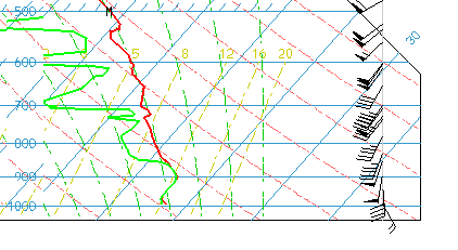
First of all, the winds found by the GPS sensor tied to the weather balloon are consistent with the UAH MIPS wind profiler and radar-derived VAD winds. The winds are not only strong, but change rapidly with height, in direction and speed. This creates a spin in the atmosphere about a horizontal axis, like a thrown spiraling football, that can be tilted upward by a thunderstorm updraft (as if the football were tipped at the line of scrimmage), causing storm rotation. Helicity values are still over 500 m2/s2 over much of Alabama, causing storms to rotate.
The balloon also shows the stability of the air at NWS office in Calera. Red is temperature, green is dewpoint. Air parcels in thunderstorms will basically have the temperature of the green dashed line it starts on (moist adiabats) since the air is near saturation at the ground. The parcel is about the same temperature as the environment as it rises, so it is fairly stable. However, with upper-level temperatures not warming much but low-level temperatures and dewpoints rising about 1 degree per hour, the air has become unstable right ahead of the front over west Alabama, and that should occur in BHM over the next couple of hours.
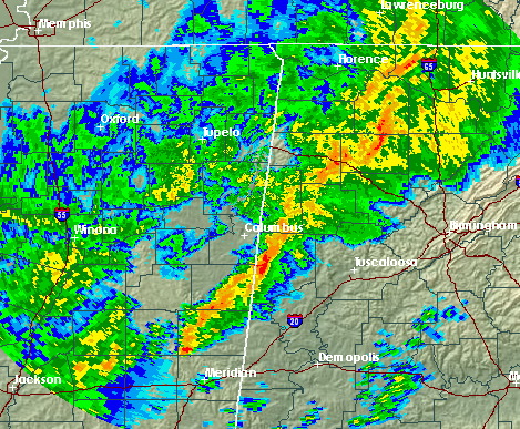
Storms will move across north and central Alabama over the next several hours, slowly progressing eastward. The ones on the leading, eastern edge of the storms will be the most dangerous. Wind damage is likely, since strong winds aloft can be brought down to the surface by downdrafts. Tornadoes continue to be possible, due to the wind shear. Several tornadoes have occurred in Mississippi, some causing damage and injuries. High winds have also caused damage.
Stay on guard with this event. With it occurring at night, it’s imperative to stay alert, and if a tornado warning is issued, take shelter.
The area of thunderstorms extends from NW AL into eastern and southern MS.