Daily Weather Briefing
Sunday, September 20, 2026
ALABAMA THIS MORNING
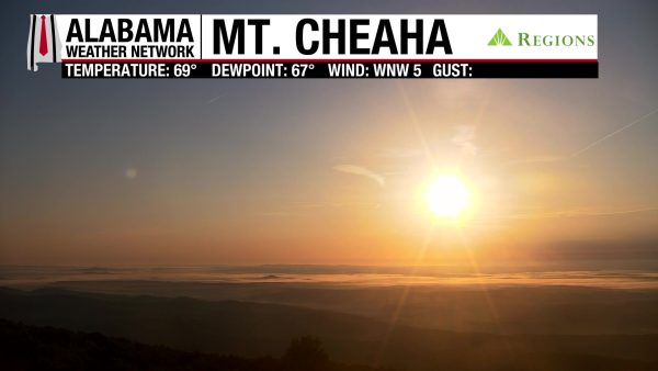
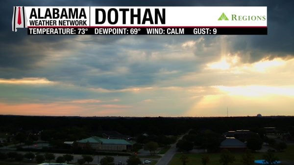
Another dry morning greets Alabama, with temperatures in the upper 60s to low 70s in the south and low 70s over the rest of the state. Skies are mostly clear over the northern two-thirds, although some patchy fog has formed in the north. South Alabama sees cloudier skies, but the sunrise still shines through. Our Mt. Cheaha and Dothan Regions Skycams are remarkable!
ALABAMA 7 DAY FORECAST
We have to endure a few more days of summer-like weather here in Alabama before a pattern change to cooler and drier weather occurs later this week. The upper-level ridge responsible for our extended hot temperatures will keep its influence over the Southeast through Tuesday, then upper-level troughing from the northeast will dig into the Southeast, pushing a cold front through the region Tuesday into Wednesday.
HOT WITH SCATTERED STORMS THROUGH TUESDAY – Sept 20-22
Today through Tuesday will feature continued hot temperatures and decent chances for scattered showers and thunderstorms each afternoon and evening.
Today, highs will rise to the low to mid 90s over most of the state and the upper 90s in northwest and west-central Alabama. Feels-like temperatures will reach a 100-104-degree range, so there is no heat advisory in effect. The Storm Prediction Center has not placed any part of Alabama under a risk for severe storms, but any storms that do develop today will be capable of producing strong winds, frequent lightning, and heavy downpours.
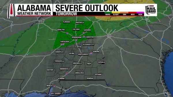
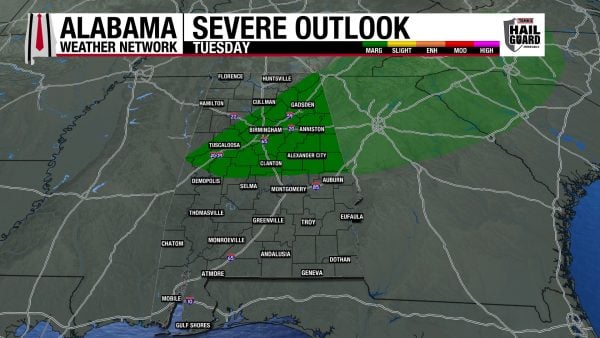
Highs on Monday will see a similar spread to today’s, with feels-like temperatures just below the threshold for a heat advisory. The entire state will have a decent chance of afternoon scattered showers and thunderstorms, but north and north-central Alabama are outlooked for a Marginal Risk (1/5) of Severe Thunderstorms that could produce damaging winds, frequent lightning, and heavy downpours.
The cold front mentioned above will begin to make its way through Alabama on Tuesday, but its effects on temperature will be felt later in the week. Highs will be in the low to mid 90s statewide. Its effects on convection will be noticeable as the Storm Prediction Center has placed northeast and central Alabama under a Marginal Risk (1/5) for Severe Thunderstorms. Just like tomorrow, the whole state could see afternoon thunderstorms, but the storms in the outlooked region could pack more of a punch.
NEW PATTERN BEGINS WEDNESDAY – Sept 23
The cold front is only expected to make it through about half of the state on Tuesday, so it will push through the rest of Alabama on Wednesday. This will lead to highs in the mid to upper 80s across north and central Alabama and highs in the low 90s over the rest of the state. Shower chances will be low but not zero.
COOLER AND MOSTLY DRY THROUGH SATURDAY – Sept 24-26
Fall-lovers, good news: highs will be mostly in the 80s from Thursday through Saturday!
On Thursday, the effects of the cold front will finally be on full display, as lows will range from the low 60s to low 70s from north to south, and highs will be in the mid 80s north and upper 80s over the southern two-thirds of the state. Rain will be very difficult to find.
Friday will feel more fall-like, with lows staying in the 60s and highs ranging from the mid to upper 80s from north to south.
Temperatures on Saturday will continue this trend: a pleasant morning with better-feeling days as highs will be in the mid to upper 80s.
Now, of course, the 80s will still be warm, but they are happily welcomed when compared to the upper 90s that parts of the state have battled recently.
RAINFALL OUTLOOK
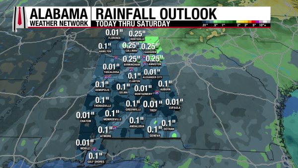
Despite the chances for afternoon thunderstorms for the beginning of this week, rainfall averages over the entire week will be quite low. Most of the state will receive between less than a tenth of an inch and a tenth of an inch of rain. Northeast Alabama looks to be the exception, as a quarter of an inch is possible in the region.
THE ATLANTIC
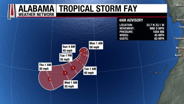
The disturbance we had been watching over the Atlantic recently has developed into a Tropical Storm, named Fay. With sustained winds of 45 mph, the storm is expected to move south-southwest over the next few days and quickly fizzle out by early Thursday morning.
THE PACIFIC
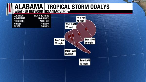
One of the disturbances we’ve been watching in the Pacific has also developed into a Tropical Storm with the name Odalys. It is expected to move northwest through Tuesday, then make a sharp turn to the northeast as it strengthens to Category 1 strength. In addition to the tropical storm, there are two disturbances in the Pacific that could develop into a tropical system over the next week. The disturbance to the east-southeast of the Hawaiian Islands has a 60% chance of development, while the disturbance close to the Mexican coast has a 90% chance.
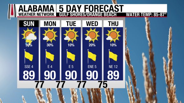
SCATTERED AFTERNOON SHOWERS, GOOD BEACH WEEK AHEAD
Today and tomorrow will have a 30% chance of scattered afternoon thunderstorms in the afternoon and evening on the coast. There will certainly be no washouts; rather, beachgoers will just have to dodge a shower or two. Today’s high will be in the upper 80s; it will be sunny, and winds will be from the south/southeast around 5 mph. The rip current risk is low, and the surf height is around 1 foot. Rain chances stay between 10 and 20% Tuesday onward.
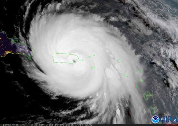
TODAY IN WEATHER HISTORY
September 20, 2017 – Hurricane Maria
Hurricane Maria made landfall near Yabucoa on southeastern Puerto Rico around 6:15 a.m. on September 20, 2017, with maximum sustained winds near 155 mph. The Category 4 hurricane crossed the island from southeast to northwest, subjecting much of Puerto Rico to destructive winds, extreme rainfall, and catastrophic flooding. Maria’s powerful circulation tore across mountainous terrain while rivers and streams rapidly overwhelmed communities.
The damage extended into nearly every part of daily life. Maria devastated Puerto Rico’s electrical grid, communications networks, roads, bridges, water systems, homes, and businesses. Mountain forests were stripped of vegetation, landslides isolated communities, and damaged bridges and roads made it difficult for emergency crews and supplies to reach some areas.
The electrical system suffered especially severe damage. Puerto Rico lost power across the island, beginning an outage that ultimately lasted about 11 months for the final customers able to receive service. It became the longest blackout in United States history, demonstrating how the failure of critical infrastructure can extend a hurricane disaster far beyond the hours of wind and rain.
The human toll also proved much larger than initially understood. The Government of Puerto Rico ultimately adopted an official death toll of 2,975 based on an excess-mortality study examining deaths in the months following Maria. The estimate reflected not only immediate storm fatalities, but deaths associated with prolonged disruptions to medical care, electricity, and other essential services. Maria showed that preparedness must protect lives at landfall and essential services afterward.
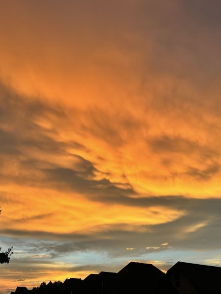
IMAGE OF THE DAY
Skywatcher Jordan Hausen sent in a picture of the amazing sunset in Chelsea after a storm moved through the area yesterday evening! It was hard to choose a favorite photo today.