


The cooler air has already started moving in, slowly, with temperatures early this morning in the lower 60s in Birmingham, with 50s in the Tennessee Valley! We’ll make it into the lower 80s today, just above the normal (upper 70s), then the more serious cool air starts to come in tomorrow. We’ll see northerly winds through Saturday morning, bringing in the colder air.
I graphed the GFS surface temperature for BHM below.
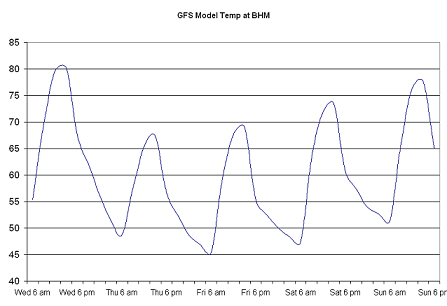
According to this model, we’ll barely make it to 70 tomorrow and Friday, with lows in the 40s 3 nights in a row! Look at Thursday night…temps below 50 for about 9 hours. For Friday night football, get the jackets ready. Kickoff temperatures at 7 pm near 60, dropping through the 50s during the game.
In what I think is a much “cooler” graphic (no pun intended), check out this high-resolution plot of NAM temperatures over the next few days over the SE. One can see temps warm up very quickly in the morning, into the 60s and even 70s, then fall quickly in the evenings. Even in the day, northerly winds are bringing cooler air south, offsetting some of the warming from the sun. Note too the mountains staying cooler in the day, the air staying much warmer over the Gulf at night (setting up land breeze), and even smaller-scale phenomena.





