


Last night, the GFS pretty much gave up the ghost on the upcoming major system that is headed our way this week. But today it kind of came back into reality with the idea of developing a major low in the Gulf of Mexico. The track and intensity of the low will determine how interesting our upcoming times turn out to be.
Tomorrow will feature a good supply of sunshine with highs in the lower 50s.
First, we will deal with a few light rain showers on Monday as the first weakening disturbance drags some upper level energy across the area. A second stronger disturbance will be heading our way during the day on Monday.
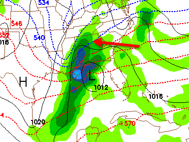
The red arrow points to the rain/snow line. That is the 540dkm 1000-500 mb thickness line, a good indication of where the rain/snow changeover will occur.
By Tuesday morning, the low will be getting its act together to the east of Brownsville, Texas. Heavier precipitation will spread into Alabama during the morning. There is a chance that the air could be cold enough for snow across parts of Alabama, perhaps as far south and east as the I-59 corridor.
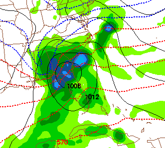
As the low moves to near Jacksonville, Florida Tuesday afternoon, colder air on the backside could drive the rain/snow line far into South Alabama. If this solution turns out to be the correct one, there will likely be significant snow accumulations across parts of North and Central Alabama. But, it is too early to be thinking specific forecasts for now. Just know that this is a possibility.
FORECAST CONFIDENCE: 3/10 (low)
POTENTIAL STORM IMPACT: Low to Significant depending on track of the low and temperature profile
This is going to be an interesting situation and one that bears watching. For now, we will call for rain or snow changing to snow, with highs in the 30s, likely falling during the day.
Dry and chilly conditions will prevail into next weekend.



