


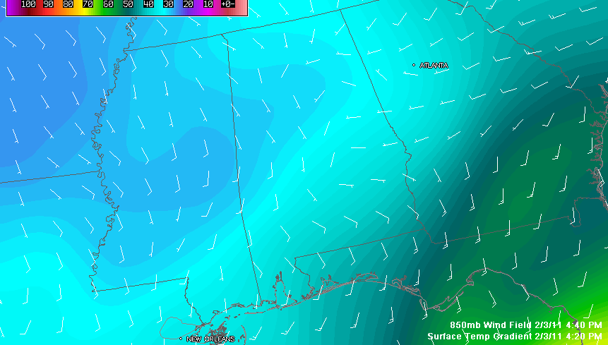
This graphic tells the story well. Winds out of the south at about 5,000 feet riding up and over the shallow cold airmass to the north and west leading to overrunning precipitation. The solid yellow line is the freezing line. Areas north and west of it are at or below 32F. The little sliver of +32F readings over Northeast Alabama won’t last long as precipitation will bring those readings below freezing rather quickly.
Chris Tombrella reports it took him two hours to go from downtown to Lakeshore/Green Springs intersection starting at 2 p.m. It is a familiar story played out across the Birmingham Metro this afternoon.
More moderate freezing rain is over West Alabama at this hour, moving to the east northeast. Here is the latest radar…
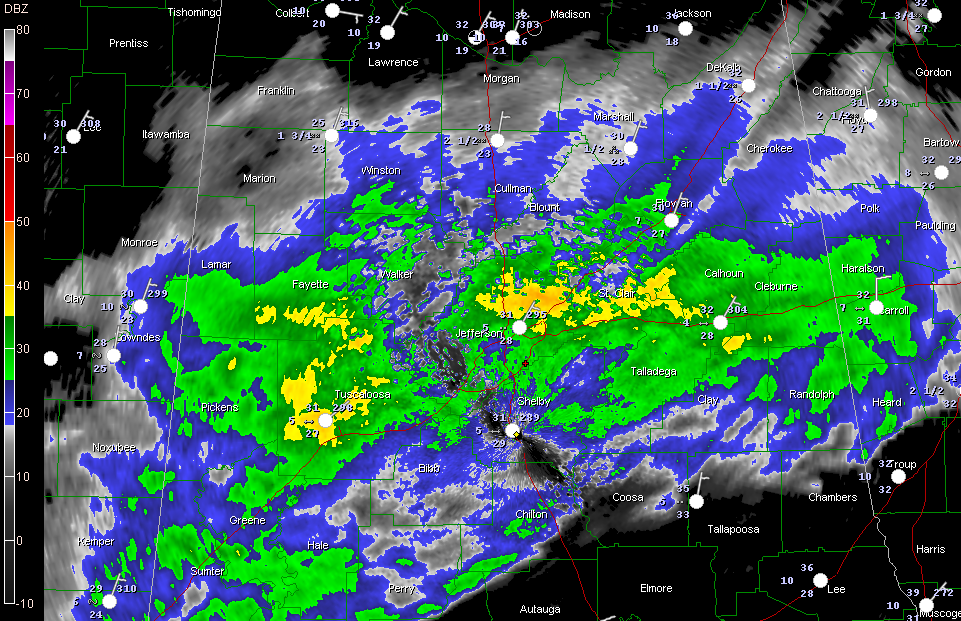
Temperatures are around 30F in the I-20 corridor. They may slowly rise through the overnight, but it could take several hours to get above freezing, if it does at all.
Daniel in Oxford reports 3 to 4 inch icicles on exposed/metal surfaces , including tree branches in Oxford.
Starting from Blount through Cullman and into DeKalb Counties it is snow. Bob Kusz says he cannot get over the size of the snowflakes, like golfballs falling from the sky at Holly Pond. Mark Huber from WVSM reports heavy snow beginning in Rainsville with big flakes, but changed to all sleet within 15 minutes.
4.5 inches of snow in Douglas according to WAFF’s Brad Travis.
Report of overturned vehicle on 431 in Wellington.
Scroll down to read Tim’s excellent analysis of the situation.
MORE LATE REPORTS
From Ric Segers…Morris 30F sleet and freezing rain. In Kimberly bridges including over Warrior River Locust Fork frozen over. On I65 mile marker 288 Hayden Corner Exit traffic at STANDSTILL NORTH BOUND DUE TO ICE IN ALL 3 LANES. South bound moving but slowly. A report from my parents in Bremen/Dodge City on Smith Lake in Cullman County exactly 1.5″ of snow on ground including driveways and roads. Temp there 29F still snow sleet and rain mix falling.
FROM EMERGENCY MANAGER MIKE LEATH
All municipal Streets within the Town of Crossville have been closed by local law enforcement officials – Co Rd 81 (Collbran Gap), Co Rd 83 (Portersville Gap) are closed by emergency responders – Al Hwy 68 up Sand Mtn from Collinsville to Crossville is closed by emergency responders awaiting arrival of ALDOT – ML
FROM THE NWS JACKSON
Laurel [Jones Co, MS] amateur radio reports FREEZING RAIN of E0.10 INCH at 04:30 PM CST — bridges along U-59 and at US 84/MS higwhay 29 intersection have iced over.
The Golden Triangle area is definitely getting a good burst of precipitation right now. Moderate freezing rain reported at Golden Triangle.



