Let’s dig into some dynamic meteorology here, before we get our last big set of models this evening before the event.
The surface low is already developing off the Texas coast, with northerly winds blowing along the Texas Coast and northeasterly winds along the Louisana coast in response to the falling pressure in the Gulf. The low may be intensifying, as winds are blowing across the isobars, toward low pressure. Precipitation is being reported as far east as Vicksburg on the Mississippi River, with Shreveport reporting a mixture of rain and snow and 34 degrees. Jacksonville and Palestine, Texas report snow this hour, with numerous other stations in Texas and Louisiana reporting rain.
Regional radar shows two areas of precipitation right now.
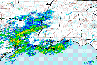
The one in the Gulf is probably associated with warm advection (which means upward motion, as warm air flows up and over cold, dense air) in the southerly flow along the front east of the low. This front will help determine the track of the low, but the front itself will move also, as south winds east of the low pull it north somewhat. Sorry map is a little off, but I had to paste two together and they were at different angles.

(SPC)
The area of precipitation on radar from western MS into Louisiana and Texas is likely associated with the right-entrance region of the upper-level jet. This is some neat stuff.


The top figure is a simplified version of a jet streak, or area of high winds in the atmosphere. The solid lines are the height lines (or isobars), and the blue arrows are the winds. Outside the jet, the winds are blowing parallel to the isobars, in balance. The pressure gradient force (PGF) pulling them toward low pressure to the north is equal to the Coriolis force (COR) caused by the rotation of the earth, pulling them to the south (forces indicated by arrows). Once the air enters the jet, the PGF increases, but since the Coriolis force is proportional to wind speed, before the wind speeds up, the PGF gets bigger than COR, and the winds deflect to the left. This does not happen outside the jet. This creates divergence aloft in the right entrance region of the jet (green area).
As shown in the bottom figure, divergence aloft pulls air upward from below, causing upward motion and precipitation. This seems to be occurring now to our west. Look at the 300 mb heights and wind speeds for 6 pm, and notice how the SE is in the right entrance region of the jet.

Some neat dynamics going on. It will be interesting to see if the front in the Gulf moves north like the 18 UTC NAM predicts, bringing the low farther north and closer to the upper level jet.
All eyes on the 00 UTC models. NAM should be in by 830 pm.