Things may be coming together for a bit of icing over parts of Alabama tonight. It’s like James says in a post below, sometimes you have to let go of the computer models somewhat and look out the window!
With clouds moving in, temperatures have not risen very quickly. At noon, temperatures are between 29 and 35 over most of central Alabama. The air is very dry at the surface, with dewpoints 10 to 15. This means wet-bulb temperatures, or the reading where the temperature and dewpoint would meet if it started raining, are 27-28 in TCL, BHM, and Anniston. Even if the temperature rises to 40 this afternoon (which may be optimistic considering clouds), the wet bulb would still be 31 or 32. This could be a problem when precipitation arrives.
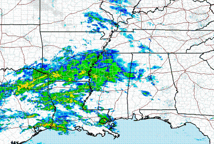
Radar shows an area of precipitation to our west, primarily due to southerly flow bringing warm, moist air northward aloft. Bridge icing has been reported in parts of Arkansas and Mississippi today, and the precipitation is reaching the ground as far east as Greenwood, MS at noon. One can see dark clouds moving in over the river at the Demopolis skycam, where the temperature is 33 degrees.

The other problem is that the warm air coming in aloft will keep the precipitation from falling as snow, as it will melt on the way down through the warm layer near 5000 feet, except maybe in extreme north Alabama. The graph below shows temperature vs. height and time, since 00 UTC (6 pm last night), from the UAH Microwave Profiling Radiometer, a neat tool that basically takes a “sounding” of the atmosphere every minute.
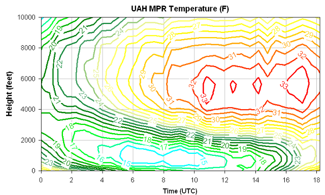
Notice that temperatures below about 4,000 feet are below freezing, but there is a layer of temperatures above freezing, that starts to come in after 10 UTC (4 am), between 4,000 and 7,000 feet. This is the layer where the precipitation will melt. The question is then, will the precipitation re-freeze before it makes it to the ground, and fall as sleet, or stay liquid until it hits the ground, and fall as freezing rain, causing icing on the ground. The icing looks more likely at this point, assuming significant precipitation makes it here. Besides, this is what is happening to our west.
Some precipitation may be begin to reah the ground as early as 3 or 4 pm in parts of west Alabama, and then in Birmingham between 5 and 8 pm. This might be a day to play it safe, if you can, and head home an hour early, especially in areas from Birmingham west. If this event plays out the way it looks now, there is at least a 40% chance of some bridge icing and travel problems tonight in the Birmingham area. The NWS in Jackson has already issued Ice Storm Warnings and Winter Weather Advisories, and the NWS in Birmingham and Huntsville will probably do the same this afternoon.

Keep an eye on this potential icing situation this afternoon. With warmer air still coming in, temperatures in BHM should rise back above freezing by noon tomorrow, so any problems will not last too long.