


Showers and thunderstorms were expected to be fairly numerous across Central Alabama this afternoon as an upper level disturbance swings across the area. So far, they have been most numerous over South Central Alabama, south of a line from Aliceville to Jemison to Eufaula, and even there they have been widely scattered at best. There was a decent thunderstorm complex over the Tennessee Valley, over Limestone, Madison and Morgan Counties.
A decent storm was straddling I-65 near Clanton. It has lots of lightning. It was stationary and will ran itself out pretty quickly, its updraft choking on its downdraft.
The stronger storms will have heavy rain, gusty winds and intense lightning. The showers and storms will likely continue into the overnight hours in some areas ahead of a front. That front extends from Indianapolis to St. Louis to Springfield MO this afternoon.
The front will push through the area overnight and Monday morning, putting the kibosh on showers and storms for the first part of the coming week as drier air filters into the area. Highs on Monday will be in the middle 90s, and we will likely shave a couple of degrees off that on Tuesday. Dewpoints will fall into the upper 50s by Tuesday morning. The drier air will allow for more radiational cooling at night. We will see 60s for lows Tuesday morning and Wednesday morning.
MIDWEEK/LATEWEEK WEATHER: A bigger upper level trough will begin to form over the eastern U.S. by late in the week, allowing another boundary to approach from the north Wednesday and Thursday. This will bring at least a chance of showers and storms back into the forecast by Wednesday afternoon, continuing into Thursday. By Friday, all eyes will be on Irene. We could see shower chances back off just a bit as sinking air out ahead of the hurricane suppresses storm development over the Southeast.
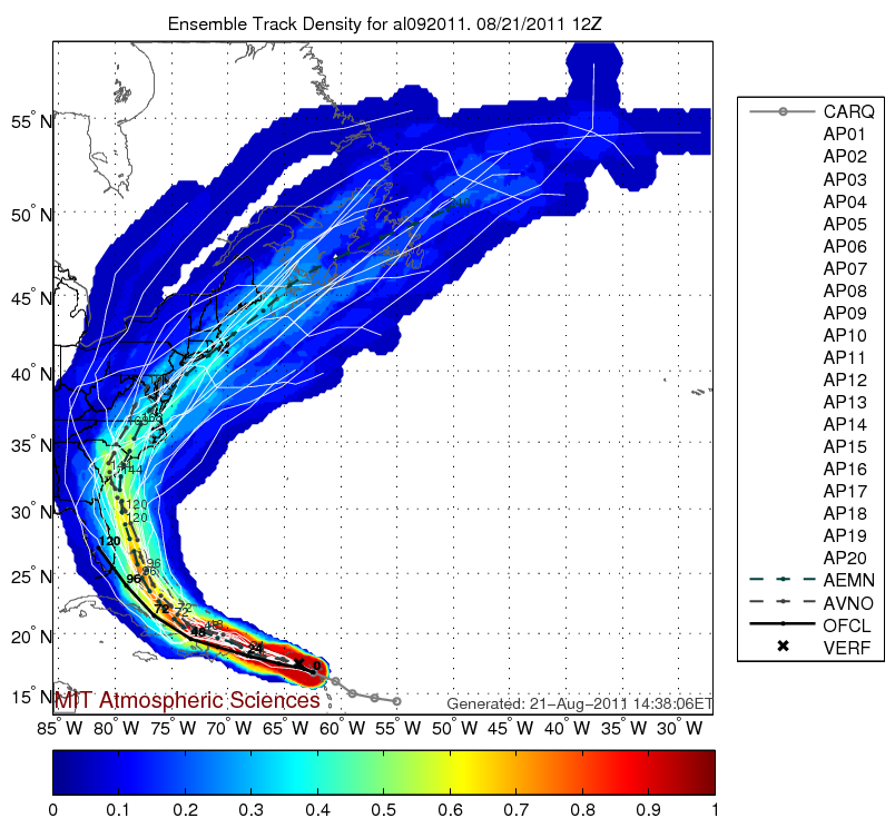
Morning ensemble run track data
WHAT ABOUT IRENE: The center of Tropical Storm Irene was approaching the Virgin Islands this afternoon. Winds gusted to 47 mph at on St. Croix at Christainsted just before noon Central time. The Air Force plane found a central pressure of 99 mb and winds of 50 mph. The storm is moving west northwest at a pretty good clip (18 mph). On satellite images, the storm still lacks big time thunderstorm activity, but it is slowly getting better organized, and should become a hurricane by tomorrow morning.
It will be tracking along the south coast of Puerto Rico and should make landfall on the eastern end of the Dominican Republic Monday morning. It will cut a path directly across the island of Hispaniola and then will cross the Windward Passage and move along the northeastern coast of Cuba on Tuesday. We will then be watching for an expected northwestward turn as a trough develops over the southeastern U.S. The official track from the NHC carries it toward Miami. It would arrive there early Thursday morning, likely as a hurricane, being rejuvenated by the warm waters of the Florida Straits.
There is excellent consensus from the models that the storm will stay north of Cuba and out of the Gulf, taking it to near Miami and then into Central Florida. Ensemble data, which slightly modifies the initial data times before running and rerunning the model hundreds of times yields an interesting result: a landfall near Savannah or along the South Carolina Coast on Friday. If that happens, it could have plenty of time to intensify and this could be a bad hurricane.



