


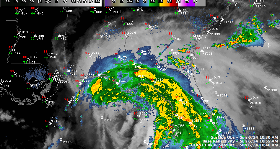
Reading Twitter this morning, it appears that Debby’s approval ratings would be lower than President Nixon’s about this time 38 years ago. Debby is throwing a chink in the plans for beachgoers from Pensacola to Southeast Florida today.
And she is no favorite of the forecasters either.
Debby has been jogging northeast this morning, edging closer to the Florida Panhandle near Apalachicola. The NHC believes that it will make a westward turn by early Monday morning and start a west northwest track paralleling the coast from Panana City until it makes landfall near the mouth of the Mississippi River Wednesday afternoon.
But the model guidance is still unclear. There are two major camps. The American model insists it will move northeast, but that has been discounted by the forecasters in favor of the European, which has seemed to have a better handle on the situation.
The key issue is whether the trough developing over the eastern United States will be able to reach down and pick Debby up, lifting it across the Florida Peninsula and out over the Atlantic. The European believes a ridge will hold to the north of Debby and shunt the storm westward.
The storm is not very organized with the heaviest rain and storms (and wind) to the north, northeast and east of the center. But that is where the coastline is and it is affecting a lot of residents and vacationers alike.
Here is some forecast, wind and closest approach point (CAP) information for several locations along the coast. I caution that it is based on the 10 a.m. official track. If Debby continues northeast like the GFS says, then the impact to areas west of Panama City will be lessened significantly. If it does go northeast, our friends in South Georgia and North Florida will rejoice at the drought busting rainfall.
Apalachicola: tropical storm force winds occurring. Widespread power outage reported on St. George Island. bridge closed. 56 mph wind gust. Storm’s CAP 8 a.m. tomorrow. 50 mph winds will be common until Tuesday morning based on current forecast. Heavy rain now will continue for quite some time. 2.31 at Apalachicola so far. Another 5-7 inches forecast for Apalachicola. Tides now running nearly 2 feet above normal at Apalachicola. Forecast is 2-4 feet. Some minor flooding reported in Apalachicola. High tide is around 7 p.m. there.
Panama City: tropical storm force winds will begin shortly. Should not get over 40-45 mph but will continue until early Tuesday morning. CAP about 95 miles south of Panama City 7-8 a.m. Monday. Panama City may see 5 and 1/2 inches of rain. Tides should run 2-4 feet above normal. St. Andrew Bay now approaching
Destin: Tropical storm force winds will begin around midnight tonight and continue until Tuesday afternoon. Winds should peak betwen 40-45 mph. CAP about 105 miles south around 6 p.m. Monday. About 6 and 1/2 inches of rain expected for Destin.
Pensacola…Tropical storm force winds begin late Tuesday morning. CAP about 10 a.m. Tuesday around 100 miles south of Pensacola. Peak winds about 40-45 mph. TS force winds end noon Wednesday. 3-5 inches of rain expected in Pensacola and Mobile. Flash flood watches just issued by the NWS Mobile for coastal Alabama and Northwest Florida.
Gulf Shores/Orange Beach…Tropical storm force winds start around noon Tuesday…may reach 50 mph or higher at times through Wednesday afternoon. CAP about 80 miles south Tuesday evening around 9 p.m. 4-5 inches of rain expected.
Tropical storm force winds will be felt over about the southern two thirds of Mobile and Baldwin Counties, including the City of Mobile and Eastern Shore.
RIP CURRENTS A DEADLY PROBLEM
Stay out of the water along the northern Gulf Coast, please. We cannot stress this enough. Despite double red flags, we will unfortunately read of drowning deaths from this storm. So unnecessary.
NHC FACEBOOK PAGE
Here is a link to the NHC Facebook Page.



