


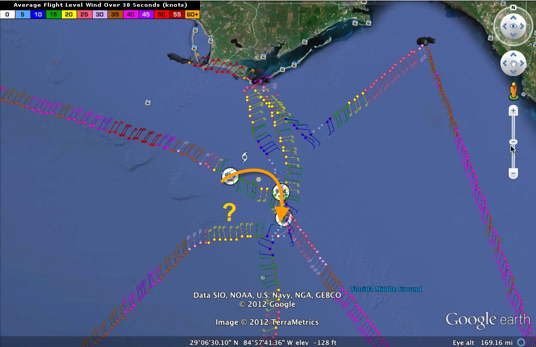
The Air Force plane is on a northbound vector to the center of Tropical Storm Debby as I start writeing this. We will get another center fix before I finish probably.
INDEED WE DID.
The three fixes on this flight describe a 15 mile jog to the southeast and then south. It seems that Debby is making a loop there over the northeastern Gulf.
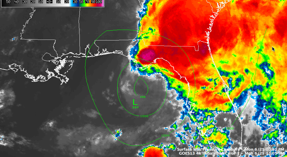
The storm is disorganized, a victim of strong wind shear and drier air that has entered the western side of the storm. It could be that it has stirred up colder water from deep in the Gulf as well.
The strongest winds measured at flight level have been well away from the center. There were some 50+ knot surface winds well southeast of the center, not far west of Tampa. The peak flight level winds were way to the northwest of the center, south of Panama City. The peak surface winds measured by the SFMR instrument have been around 45 mph.
The central pressure is now 992 millibars according to the recon penetration at 10:59 p.m. Could Debby be strengthening a bit as it loops? But it can’t strengthen much, since the storms are not co-located with the center.
The intense thunderstorms that developed on the northern side of the center today over the Florida Panhandle are showing some signs of weakening now finally. But the flooding is historic in parts of the NWS Tallahassee’s area of responsibility. Here is a note from their chat at 9 p.m. tonight:
MEDIA: we could use your help in conveying the urgency of this situation. This is NOT a normal flooding event, particularly in Wakulla County. We are extremely concerned about how this is unfolding. For reference, the Sopchoppy River will exceed the previous record crest in Wakulla County by 10 feet and the major flood stage by 7 feet. ***Just because people did not receive flooding problems in previous flood events, does NOT mean they won’t in this case** If the heavy rain continues into the morning, that 41 foot crest could potentially be underdone
Doppler radar estimates indicate that as much as 30 inches of rain has fallen near Sopchoppy in Wakulla County. Water has entered homes in Sopchoppy and the NWS Tallahassee continues a flash flood emergency for Wakulla County.
Incredible rainfall report: 2 NW Panacea-Wakulla AI [Wakulla Co, FL] mesonet reports HEAVY RAIN of M20.63 INCH at 11:43 PM EDT — 20.63 inches of rain in the last 24 hours.
Another…1 ESE Sanborn [Wakulla Co, FL] mesonet reports HEAVY RAIN of M20.10 INCH at 11:46 PM EDT — 20.10 inches of rain measured over the last 24 hours.
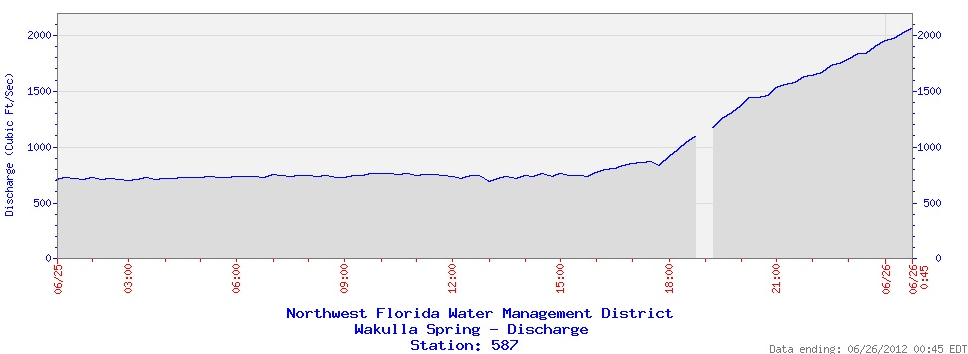
How about this? Wakulla Springs is on the verge of breaking its all-time peak discharge of 1910 ft3/s set on 4/13/1974.
OTHER REPORTS
…water inundating areas around the highway 98 lower bridge just wnw of st. marks.
…4 SE Crawfordville [Wakulla Co, FL] nws employee reports TROPICAL STORM at 07:00 PM EDT — flooding reported at highway 98 and spring creek highway. water at a gas station was to the level of the gas pump handles. it is unclear whether or not this was related to heavy rain…storm surge…or a combination of both.
…at 11:01 p.m…getting a lot of observations with tropical storm force gusts now along the Franklin County coast. Velocities have been increasing on radar. Could be that Debby is strengthening.
…Disturbing report from gauge on Sopchoppy River indicates that stage has fallen three feet in the last hour. Probably indicates the gauge is obstructed with debris or has failed completely. From the NWS Tallahassee: ongoing moderate rainfall and a recent call from a farmer indicating creeks were still “roaring” into the Sopchoppy River make the falling stage report “doubtful”.
Here are the 10 p.m. particulars on Debby:
SUMMARY OF 1000 PM CDT…0300 UTC…INFORMATION
———————————————–
LOCATION…29.2N 85.1W
ABOUT 35 MI…55 KM S OF APALACHICOLA FLORIDA
ABOUT 120 MI…195 KM W OF CEDAR KEY FLORIDA
MAXIMUM SUSTAINED WINDS…45 MPH…75 KM/H
PRESENT MOVEMENT…NE OR 40 DEGREES AT 2 MPH…4 KM/H
MINIMUM CENTRAL PRESSURE…992 MB…29.29 INCHES


