


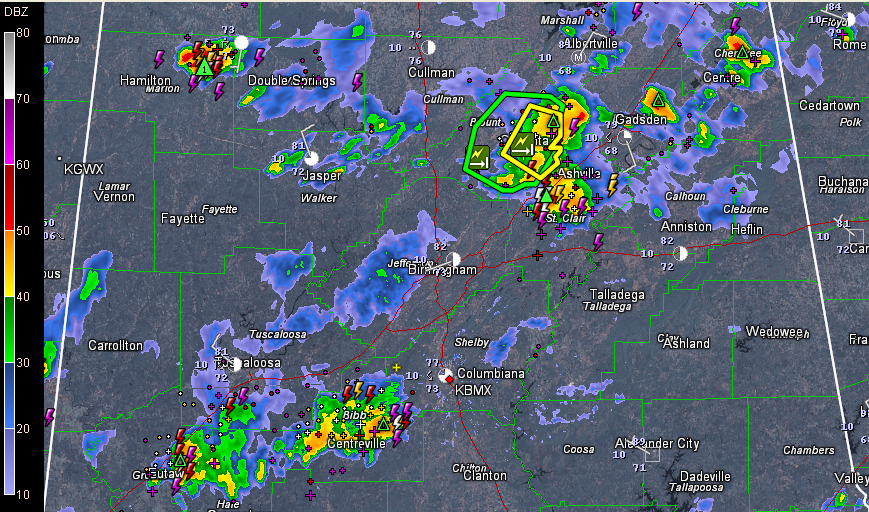
Storms continue across parts of Central Alabama this afternoon.
They are strongest over Blount County where a severe thunderstorm warning will expire at 5 p.m. and a flash flood warning continues in effect until 8 p.m. There have been a couple of reports of wind damage, including trees and power lines being downed by this storm, which is centered near Altoona now. Quarter sized hail was reported just northeast of Oneonta as well. It has definitely peaked and is weakening now.
In St. Clair County, part of that same storm extends from north of Odenville to near Wattsville down to near Pell City. It will move to near Ragland and Riverside shortly. Any folks on Lake Logan Martin need to come off the lake and be indoors right now.
Storms over Marion County are quite strong and close to being severe. The storm is south of Hackleburg and Bear Creek and will pass south of Haleyville on its way to around Natural Bridge. This storm seems to have peaked and is probably most capable of producing damaging winds right now. It shows some signs of hail approaching severe limits (one inch) as well.
Elsewhere, strong storms are over northern Greene and Hale Counties extending into Bibb County. Lots of lightning with these, but so far they seem to be below severe limits.
If you’re lucky enough to get near one of these, just be careful. Stay indoors until the storm passes. Stay away from windows, off the telephone and away from electrical and plumbing. Otherwise, enjoy the rain and the gift of nature’s air conditioning!



