


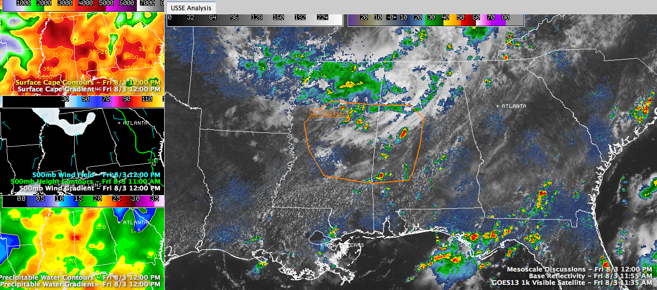
Click to enlarge
Storms are starting to develop over West Central Alabama early this afternoon. One has quickly developed in Tuscaloosa County south of Coaling. It is already quite heavy with lightning and heavy rain.
It will push southeast into western Bibb County.
The SPC says a severe thunderstorm watch is probable soon over eastern Mississippi and western Alabama. The area shown in orange in the large panel of the graphic is the general area.
Storms are going to be most likely in the area just ahead of the cloud mass with the thunderstorm complex over northern Mississippi. There you have more sunshine, which means additional energy to fuel the thunderstorm updrafts. You can see that is exactly where the Tuscaloosa County storm has formed.
Stronger winds are moving in aloft, which will help the storms stay organized. Damaging wind and hial will be the primary threats.
Here is the full SPC mesoscale discussion text.
MESOSCALE DISCUSSION 1690
NWS STORM PREDICTION CENTER NORMAN OK
1156 AM CDT FRI AUG 03 2012
AREAS AFFECTED…CENTRAL PARTS OF MS/AL
CONCERNING…SEVERE POTENTIAL…WATCH POSSIBLE
VALID 031656Z – 031800Z
PROBABILITY OF WATCH ISSUANCE…60 PERCENT
SUMMARY…TSTMS ARE EXPECTED TO INCREASE IN COVERAGE ACROSS CENTRAL
MS INTO CENTRAL AL THIS AFTERNOON WITH THE POTENTIAL FOR A SEVERE
WEATHER THREAT. WW ISSUANCE IS BEING CONSIDERED FOR THIS AFTERNOON.
DISCUSSION…VISIBLE SATELLITE IMAGERY SHOWED AN INCREASE CU
DEVELOPMENT FROM NORTH CENTRAL MS /JUST S OF THE CLOUD SHIELD/ SEWD
INTO WEST CENTRAL AND SRN AL…AND SERN MS. THIS CORRIDOR OF DEEP
CU FORMATION WITH A FEW TSTMS ALREADY DEVELOPING PER REGIONAL RADAR
IMAGERY AND LIGHTNING DATA. THIS ACTIVITY IS LOCATED ALONG A SUBTLE
SURFACE TROUGH WITH FORCING FOR ASCENT ATTENDANT TO A SSEWD MOVING
MCV OVER NWRN AL AND LOWER TROPOSPHERIC WEAK WAA S OF THIS FEATURE
WILL SUPPORT ADDITIONAL TSTM DEVELOPMENT THIS AFTERNOON. MODIFIED
12Z JAN RAOB SUGGESTED SURFACE TEMPERATURES RISING INTO THE UPPER
80S WOULD BE SUFFICIENT TO WEAKEN INHIBITION…AND THESE TRENDS ARE
NOW BEING OBSERVED PER TSTM DEVELOPMENT AND TRENDS IN OBJECTIVE
ANALYSES. EFFECTIVE BULK SHEAR OF 25-30 KT SAMPLED BY THE VWP/S AT
NQA AND GWX SUGGEST MULTICELLS WILL THE DOMINANT STORM MODE WITH AN
ATTENDANT THREAT FOR DAMAGING WINDS AND HAIL.
..PETERS/THOMPSON.. 08/03/2012



