


Lots of interest in the future track of our tropical storm which is now in the Caribbean.
Here is the spaghetti plot of the various model tracks.
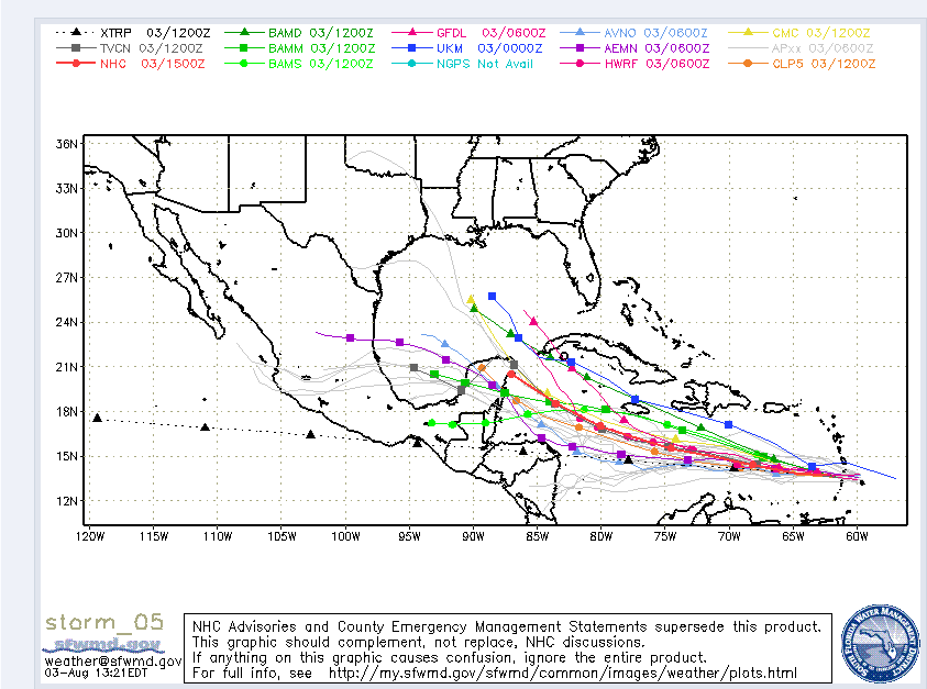
There has been good agreement that the storm will get into the northwestern Caribbean. The official track forecast takes it to the Yucatan early Wednesday. That is the end of the official 5 day forecast from the NHC.
Thunderstorm activity seems to be increasing today. The center is well defined. It appears to be surviving in the rather hostile environment over the eastern Caribbean, so one would think when the shear relaxes in a couple of days that it will strengthen. The official forecast has it strengthening to a hurricane by early Monday.
Looking at the morning run of the GFS, it has the storm taking a more southerly track over the western Caribbean which leads to interaction with land. It moves it over the Yucatan at a lower latitude and moves it slowly across the land mass, emerging over the southwestern Gulf of Mexico next Friday before crossing into southern Mexico.
The morning run of the Canadian has come into line with this thinking. It carries it into southern Mexico.
Still have not seen the morning run of the European.
The morning run of the HWRF definitely takes it into the southern Gulf of Mexico but apparently on a bearing for the middle Texas coast.
Bottom line, there is lots of uncertainty in the long range portion of the forecast for Ernesto after it gets into the western Caribbean. Hopefully, things will become clearer as we head through the weekend.
It certainly would not make me change any plans along the Gulf Coast for next week. But everyone with interests along the Gulf Coast will want to pay attention to Ernesto.
Interestingly, there is another system behind Ernesto that shows potential for development.



