


**No afternoon Weather Xtreme video today due to travel and the active weather we have dealt with in recent hours**
REMEMBER: Often I say… “When it comes to thunderstorms… expect the unexpected…” The big MCS that moved through Alabama today quite frankly was not forecast well by computer models or humans. There was a little wind damage in northern Tuscaloosa County near Samantha… and up in Lauderdale County in Northwest Alabama. But, the summer rain was good and temperatures are over 20 degrees below average in some places at mid-afternoon. Tuscaloosa is reporting only 72 degrees at 3:00.
The storms weakened as they moved east of I-65, where the air is a little drier and more stable over East Alabama. The severe thunderstorm watch that was issued for much of Central Alabama has been cancelled.
TONIGHT AND TOMORROW: I am not sure the computer models still have a good grasp on the situation. Looks like SPC is about to issue another severe thunderstorm watch for lower Mississippi River region… see the graphic below…
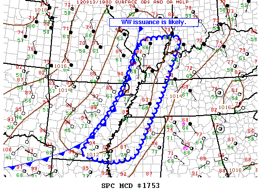
These new storms should work their way in here late tonight or early tomorrow morning; I would suggest the main window for our part of Alabama will come from about 9:00 p.m. through 9:00 a.m. The storms could be strong, like the ones we saw earlier today.
Drier air should work into the northern half of the state tomorrow afternoon as the storms move south. We won’t get out of the 80s tomorrow as temperatures remain below average.
WEDNESDAY/THURSDAY: These two days continue to look dry with highs in the 89 to 92 degree range with partly to mostly sunny days and fair nights.
FRIDAY AND THE WEEKEND: The 12Z GFS shows another increase in moisture with a chance of showers and storms on Friday and Saturday. It remains to be seen if the surface front can move south of here; the drying for Sunday and Monday is somewhat in question… we will keep it mostly dry in the forecast and can fine tune it later. The rain Friday and Saturday won’t be continuous, but it could rain at any time, and a strong storm is possible. The weather pattern really looks more like late September instead of mid-August across North America. The high Friday will be near 90, with 80s over the weekend.
Still no sign of any excessive heat through the rest of August, which is great news for our state. You can watch the morning Weather Xtreme video for the graphics and details.
GULF COAST WEATHER: For the area from Panama City to Gulf Shores, expect about 4 to 6 hours of sunshine each day through the weekend, and you will have to dodge scattered showers and thunderstorms on a daily basis. The chance of any one spot getting wet each day will be running in the 30 to 40 percent range, and highs will remain generally in the upper 80s along the immediate coast. Sea water temperatures are mostly in the mid 80s.
TROPICS: The Atlantic basin is generally quiet… but there has been a slight increase in the amount of convection in Tropical Depression 7 over the Caribbean today. If something tries to regenerate, it will wind up over Central America, or the Yucatan, much like Ernesto.
WEATHER BRAINS: Don’t forget you can listen to our weekly 90 minute netcast anytime on the web, or on iTunes. This is the show all about weather featuring many familiar voices, including our meteorologists here at ABC 33/40. We will record tonight’s show at 8:30 p.m. CDT… you can watch live here.
CONNECT: You can find me on all of the major social networks…
I had a great time today visiting Mississippi State University… I spoke at the annual summer broadcast meteorology workshop. Look for the next Weather Xtreme video here by 7:00 a.m. tomorrow…



