


Writing this update from home on my wife’s aluminum iMac. This thing is nice! I will be heading into the office at ABC 33/40 shortly for the long night; Ashley B is there now.
Wanted to show the 12Z sounding for Birmingham (from the Shelby County Airport)…
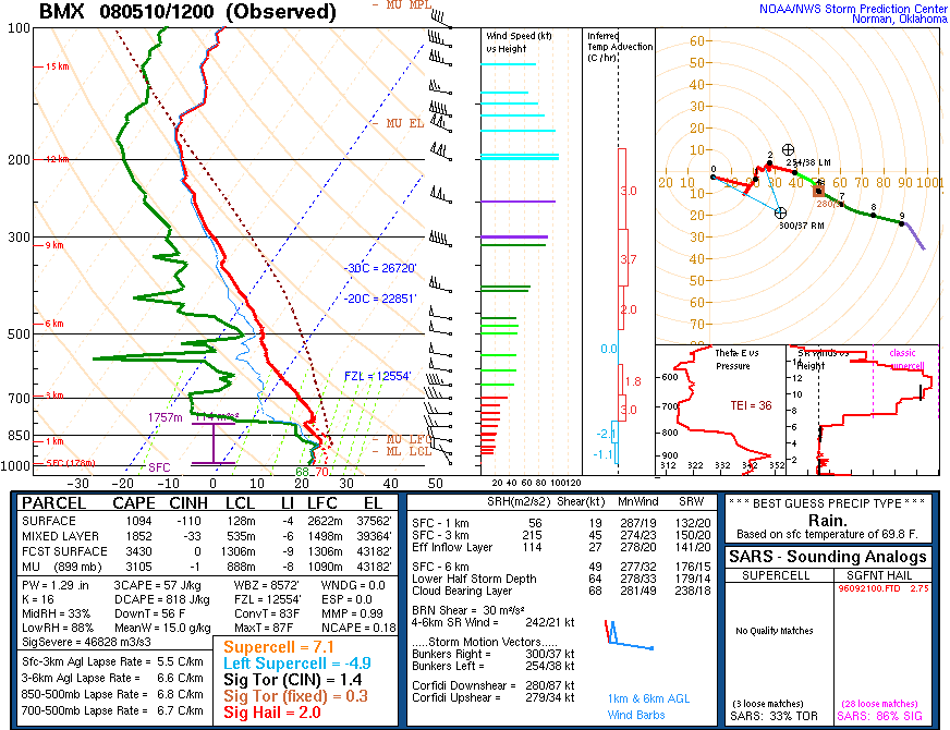
This is a meteorologist’s playground… but unfortunately these soundings are normally taken only twice daily, at 7am (when this one was taken) and 7pm local time.
Note there is a cap, which is keeping a lid on storms for now, and also not much low level shear early this morning. But, the atmosphere will change greatly this afternoon and tonight as the upper air dynamics approach. The RUC shows the best shear values for rotating storms still to the west at this moment.
Note the forecast CAPE value for this afternoon is 3,430 j/kg with a lifted index of -9 (C). That sure makes for an explosive atmosphere. Sure seems like we are sitting on a powder keg with 70 degree (F) dewpoints along and south of our stalled boundary over North Alabama.
I honestly think that the SPC idea of a derecho/major wind damage event for Alabama tonight is a good one, but you sure can’t rule out tornadoes in this kind of setup.
It still looks like the greatest threat for Alabama will come in the 9:00 p.m. to 9:00 a.m. time frame, but I can’t rule out a few discrete cells this evening that could go severe. So, everyone will need to stay alert.
LIVE STREAM: We are going on the live stream on abc3340.com at 7:00 this evening to discuss this event in detail… of course, you can see our radar on the stream anytime we are not using it for severe weather or breaking news coverage.
Stay with us for updates through the day and tonight!



