


I think we have avoided storms most of the day today due to a small layer of warm air near 3,000 feet, called a cap. In the sounding below, the temperature is the red line, the dewpoint is green, and the temperature a rising parcel would have is blue. Note that, near 900 mb, a parcel would be slightly cooler than the environment, and buoyancy would cause it to sink.
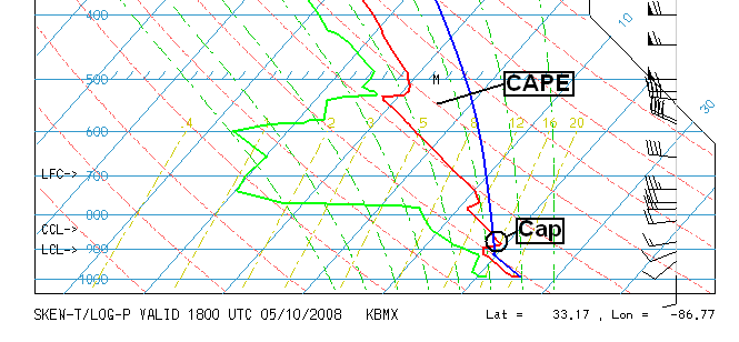
Other than that, the atmosphere is very unstable, with CAPE values of 2,000 to 3,000 J/kg over central Alabama. If any parcel could break through the cap, it would form strong storms very quickly. With sunset, the winds may have changed just a little, helping a few storms to form along the front, but this still doesn’t look like the main action, as wind shear is not that high yet.
This does not mean you should let your guard down about the severe weather. Once the main storm system moves in later tonight, wind shear will increase, and the cap will disappear, so expect severe storms to move in. The timing discussed by James and JB looks right on. The storms will have the possibility of damaging winds and large hail, and some tornadoes with the wind shear. The fact that no storms formed today means all of the energy will still be there when the storms come through later.
I’m headed to the TV station soon also.



