



UPDATE: Spotty damage reports coming in from Clay County. Public reports of a tree down on power lines on Blakes Ferry Road. Use extreme caution if you are out and about, as there could be more trees and power lines down as well as some flooded roadways.
A severe thunderstorm capable of producing damaging winds is impacting Clay County. This included the cities of Miilerville, Ashland and Lineville as well Highways 9, 77, 49 and 7. Along with damaging winds, hail, intense rain and dangerous lightning will accompany this storm as it tracks east across the county.
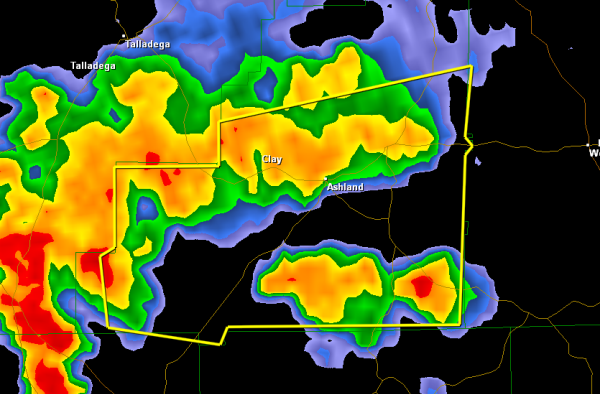
THE NATIONAL WEATHER SERVICE IN BIRMINGHAM HAS ISSUED A
* SEVERE THUNDERSTORM WARNING FOR…
CLAY COUNTY IN EAST CENTRAL ALABAMA…
* UNTIL 545 PM CDT
* AT 455 PM CDT…THE NATIONAL WEATHER SERVICE INDICATED A SEVERE
THUNDERSTORM CAPABLE OF PRODUCING DAMAGING WINDS IN EXCESS OF 60
MPH. THIS STORM WAS LOCATED NEAR PARKDALE…OR 6 MILES NORTH OF
GOODWATER…AND MOVING EAST AT 25 MPH.
* LOCATIONS IMPACTED INCLUDE…
ASHLAND…LINEVILLE…BARFIELD…ROSELLE…CLEVELAND CROSSROADS…
MILLERVILLE…SPRINGHILL AND MELLOW VALLEY.
WINDS OF 60 TO 70 MPH WILL BREAK LARGE TREE LIMBS AND CAUSE SOME
DAMAGE…ESPECIALLY TO SMALLER STRUCTURES.
PRECAUTIONARY/PREPAREDNESS ACTIONS…
FOR YOUR PROTECTION…MOVE TO AN INTERIOR ROOM ON THE LOWEST FLOOR OF
YOUR HOME OR BUSINESS.



