


An all new edition of the ABC 33/40 Weather Xtreme video is available in the player on the right sidebar of the blog. You can subscribe to the Weather Xtreme video on iTunes by clicking here.
COLD AIR GETTING CLOSER: What a map today… the long awaited Arctic front is near Muscle Shoals as I write this.
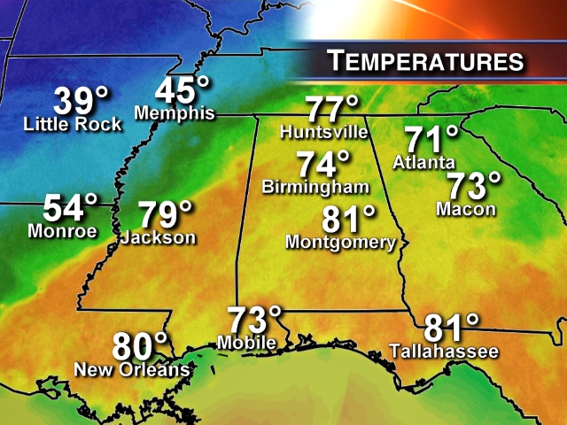
Temperatures are flirting with 80 degrees over parts of West Alabama, but we are now seeing 40s over North Mississippi behind the front. Temperatures will fall into the 30s over Northwest Alabama tonight, but elsewhere the weather will stay warm and humid with occasional showers and thunderstorms.
STRONG STORMS POSSIBLE: The Storm Prediction Center has gone ahead and issued the standard “slight risk” of severe weather for North and Central Alabama for the rest of the afternoon and tonight. The threat remains somewhat marginal, with less than impressive lapse rates and wind fields. Also, the higher low level helicity is back in the cold air. But, anytime you have upper 70s and low 80s in December (the core of our fall tornado season), you have to keep an eye on the radar.
We have noted a few storms with broad rotation this afternoon, but nothing too prompt a warning.
Strong storms remain possible over East and South Alabama tomorrow ahead of the Arctic front.
SOAKER TOMORROW; COLD AIR MOVES SLOWLY SOUTH: As noted here over the past several days, we could see a 40 to 50 degree temperature swing across Alabama due to the Arctic boundary. A good chance at midday Muscle Shoals will be in the 30s, while Montgomery is in the 80s. For Tuscaloosa and Birmingham, we start the day warm and humid, but temperatures will fall into the 40s tomorrow afternoon.
Areas east and south of Birmingham will stay warm through most of the day tomorrow, with a high well into the 70s. A one number forecast just won’t cut it.
And, tomorrow will be very wet with rain likely throughout the day. Thunderstorms are possible where the warm air lingers.
TO THE WEST: Ice storm warnings remain in effect for parts of Southeast Oklahoma, Northeast Texas, Central Arkansas, and West Tennessee. Cities like Little Rock and Memphis could see significant accumulations of ice, and travel will become difficult, if not impossible tonight and tomorrow. Winter storm warnings are up from West Texas to Ohio as a very messy winter weather situation continues to unfold.
ICE IN NORTHWEST ALABAMA TOMORROW NIGHT? I still think we will see some freezing rain (rain that falls with temperatures at or below 32 degrees) tomorrow night west of a line from Sulligent to Haleyville to Moulton to Hazel Green. While this probably won’t be a big issue (no power outages, etc), it could create some bridge icing, so if you will be traveling in this part of the state be very aware of the possibility.
COLD, DAMP SATURDAY: Saturday will be cloudy, cold, and wet with periods of light rain. Nothing too heavy, however, as the initial wave will be east of the state. We won’t get out of the 40s.
MORE RAIN SUNDAY: The next wave will push a warm front northward through Alabama Sunday, meaning another day with temperatures all over the board. I think the cold air will stay over Northwest Alabama with 40s, and cold air damming will keep Northeast Alabama in the 40s as well. But, warmer air moving up from the south could bring temperatures up into the 50s, and maybe near 60 as far north as Birmingham and Anniston by late afternoon. The warm front means more rain, and it looks like a soaker.
We will have to watch for potential flooding issues by Sunday night as the ground will be saturated and the rain keeps falling.
SUPER SIX FOOTBALL: So far, there has been little rain in Tuscaloosa today, but we will forecast a chance of showers, and possibly a thunderstorm for tonight’s game with temperatures falling into the 60s. For tomorrow afternoon and tomorrow night, rain is likely, and temperatures will fall into the 40s by afternoon, with upper 30s likely tomorrow night. It will be a cold and wet day for football.
SEC CHAMPIONSHIP: Of course, Saturday’s title game in Atlanta which features Auburn vs Missouri will be played in the dome, but for fans headed over that way the day will be wet with light rain at times and a high around 50 degrees.
NEXT WEEK: The rain keeps falling Monday over Alabama. It finally winds down Monday night; storm totals in the 3 to 5 inch range are likely over the northern third of the state.
And, as the rain moves out Monday night, much colder air moves in. We could see a few snow flurries Tuesday morning, and Tuesday promises to be a cold, windy day with temperatures struggling to get out of the 30s over North Alabama. Wednesday morning will be cold with an average low near 20 degrees, and teens for the colder valleys.
It will be nice to have the sun back in full force Wednesday, even though the weather stays cold with a high in the 40s.
WEATHER BRAINS: Don’t forget you can listen to our weekly 90 minute netcast anytime on the web, or on iTunes. This is the show all about weather featuring many familiar voices, including our meteorologists here at ABC 33/40.
CONNECT: You can find me on all of the major social networks…
Facebook
Twitter
Google Plus
Instagram
I had a great time today visiting with the pre-schoolers at Attalla Elementary; be looking for them on the Pepsi KIDCAM today at 5:00 on ABC 33/40 News. The next Weather Xtreme video will be posted here by 7:00 a.m. tomorrow…



