


THE SETUP: Another area of high pressure is moving out of Canada today and bringing with it more cold air. We have an upper-level low over the Great Lakes today. It will be sending a cold front south and that cold air will begin to move in overnight. You will notice the cooler temps tomorrow. A precursor to the main event, in portions of northwest Alabama where the colder air pushes in and where some showers develop overnight, there could be some patchy areas of freezing rain tonight. This would be for locations in Marion and Winston counties and to the north. Nothing major and it will be short-lived, but use caution during the early morning hours as a few slick spots will be possible. By mid-morning, temps will rise above freezing and allow any ice coating to melt. Off to our southwest a feature will be developing and sending moisture north. Cold air and moisture over-lapping is never a good thing and will be what we see.
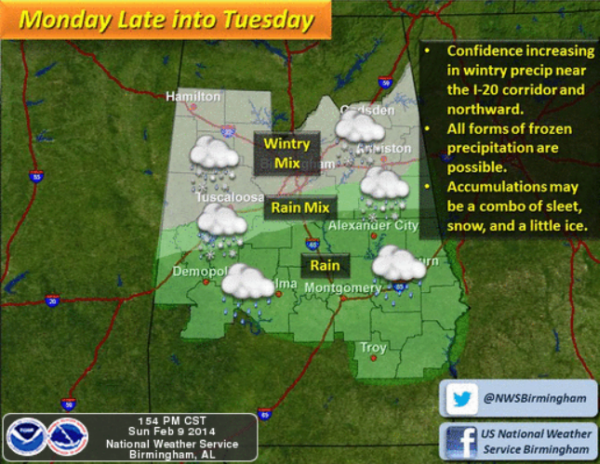
POSSIBLE SCENARIOS: This is such a tricky forecast, because the heavy populated areas along Interstate 20 corridor on the southern edge of the overall event so there are several possibilities for different precip types. The best advice I can give today, it to expect the worse and hope for the best.
This is a very high impact forecast so let’s drill down to what the latest model runs have been showing. While working on the forecast yesterday, the GFS was showing a mostly snow event for Birmingham. As we moved through the overnight and morning hours, the models show warm air will be nosing in from the south above the surface. This is a problem because this means the snow will melt as it falls through the warm layer, but the surface will be at or just below the freezing mark. This is a classic recipe for freezing rain and it appears this will happen along the Interstate 20 corridor. This is the worst kind of winter precip as it coats everything in ice and there could be some significant icing in these areas. I would make no plans to be out and about late Monday and into Tuesday morning. Let the event finish and allow our temps to warm up enough. The rain will continue most of Tuesday, but temps will climb above freezing by late morning and this will turn into a rain only event.
Being on the southern edge of the affected area is similar to the issue we had a couple of weeks ago. A slight shift in the system and we could be go from freezing rain and snow, to all rain or to all snow. Very hard to forecast, but we see model consistency and that the potential for icing is near Interstate 20 corridor is significant. Expect areas to the north to have all frozen precip including sleet and snow, while area to the south will see all rain. Once again, areas along the Interstate 20 corridor is where the temperature profiles are the trickiest.
The northern part of the state which includes the Tennessee Valley and areas along and north of U.S. 278 should see all snow, and the models are hinting at a heavier band of snow developing. That heavier band of snow I think will set up between Birmingham and Cullman. One to three inches of snow is likely and of course there will be someone that could receive more.
Just south of the Interstate 20 corridor, there will be a rain/sleet/snow mix, but during this time, surface temps are expected to be just above freezing and accumulations are not currently expected. This area would include locations in Talladega, Shelby, and Bibb counties.
At this time, much of Central Alabama, which includes, Demopolis, Clanton, Alex City, Auburn, Selma, Montgomery and Troy this appear to be an all rain event. The cold air is not expected to make it that far south.
The NWS in Birmingham did extend the Winter Storm Watch from 3 PM Tuesday until 6 PM Tuesday evening.



