


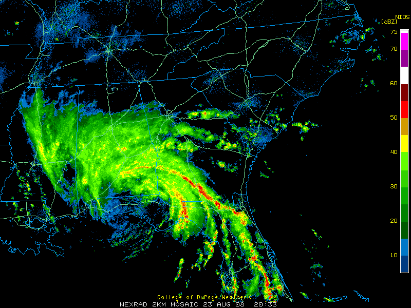
Using surface observations…the diffuse center of Tropical Storm Fay appears to be between Crestview and DeFuniak Springs in northern Florida. It appears that the storm has been moving northwest for the past few hours.
Moderate rain continues over Central Alabama south of I-20 this afternoon. Heavier rain is over the Southeast part of the state with the heaviest rain over Crenshaw, Pike, Barbour, Bullock and Russell Counties.
Top winds are still carried at 45 mph in the new advisory that is out, but the winds are beginning to spin down.
It is still breezy over South Central Alabama…
In Montgomery…winds were NE at 21 gusting to 31 mph. In Greenville, winds were NNE at 16 gusting to 33 mph with a peak gust of 38 mph. In Dothan winds were east at 24 gusting to 37 mph. In Troy, winds were east at 21 gusting to 32.
Other observations…
Crestview…NNW 12
Panama City…SW at 7
Flash flood warnings continue for parts of Pike and Barbour Counties. 3.04 inches of rain so far at Troy, with 1.10 in the last hour. A new flash flood warning has been issued for Bullock County. The heaviest rain in Southeast Alabama is moving into Bullock County at this time.
REPORTS
…17 inches of rain in Cairo GA.
…10.50 inches of rain on the FSU campus in Tallahassee as of 1:30 p.m. CDT.
…Several reports of flooding in Tallahassee.
…Roads under water in Colquitt in Miller County, GA.
TALLAHASSEE
…7.14 inches at the Tallahassee Regional Airport as of 3 p.m. CDT. This has erased the rainfall deficit for the year.
…The 3.03 inches that fell yesterday at Tallahassee was a record for the date.
…The main band of torrential rains has shifted just east of Tallahassee as of 3:30 p.m.
FOR CENTRAL ALABAMA…
The center of Fay should continue to move northwest into Southwest Alabama and eventually into Southern mIssissippi overnight near Jackson by tomorrow morning. By then, the steering currents are expected to collapse, and the remnant low from Fay will drift for the next few days.
We will still be in a favorable position for more rains tomorrow. The rainfall will diminish a bit tomorrow night, but it will be back on Monday, with more rain likely.
When will Fay turn northeastward? The GFS predicts that it will be on Tuesday. The NAM is slower. Conditions will improve when the low moves off to the northeast. Until then, the low will be capable of producing tremendous flooding rains.
All Alabamians should remain weather alert until the threat from Fay goes away.



