


The evening run of the GFS model has shifted significantly east…carrying Ike to the northwest, but turning it north late in the week and stalling it off the Southeast Louisiana coast into the weekend, waiting on a bigger trough that has reappeared in the modeling.
This is the track I have the most confidence in right now. While there are lots of plausible outcomes, this one makes a lot of sense to me. It brings a lot of rain and wind to Alabama late in the weekend.
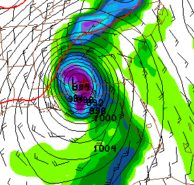
Here is the output for 180 hours…o rMonday morning. It shows the center near Atmore over South Alabama.
If you wait long enough, you can find a model to forecast any scenario you can think of. Only time will tell.



