


ALABAMA WEATHER FORECAST
North Alabama starts with upper 50s and 60s this morning, with only patchy valley fog. A few light radar returns have been noted, and there remains a low chance for a stray shower or storm later today or this evening. Otherwise, skies turn partly to mostly sunny with highs in the upper 80s to near 90.
In southern Alabama, sunshine dominates and conditions stay dry. Afternoon highs will be similar, ranging from the upper 80s to lower 90s, with overnight lows in the 60s.
Along the Gulf Coast, it’s another warm day with highs near 90 and light northeasterly winds. Seas remain low, and the rip current risk stays minimal through the week.
Looking ahead, warm and mostly dry weather persists through midweek. By late week, a cold front pushing out of the Plains will bring the next chance for showers and storms Friday into Saturday, followed by a modest cool-down.
DANCING WITH THE STATS
Saturday’s heat rewrote the record books across the central U.S. Vichy-Rolla, MO climbed to 97°, breaking its 1956 record. Valley, NE reached 94°, surpassing the 1994 mark, while Des Moines, IA tied its daily record of 96°, a value also logged in 1939, 1931, and 1897. Minot, ND added to the warmth with a new record warm minimum of 64°, edging past a 1927 record.
Daily rainfall records also fell. Mobridge, SD soaked up 2.21 inches, more than double its 2008 record of 0.96 inches. Garden City, KS also set a new mark with 0.97 inches, topping the previous record from 1970.
NATIONAL FORECAST
STORMS TARGET THE PLAINS WITH FLOODING THREAT
Rounds of thunderstorms continue today across the Plains as an upper trough pushes out of the Rockies. A developing surface low over South Dakota organizes storms into the northern Plains later today and tonight. The western Dakotas are under a slight risk for excessive rainfall, where deep moisture and repeated downpours could overlap areas already soaked on Saturday, raising the flash flood potential. A broader marginal risk stretches southward across the central and southern Plains into Texas, where slow-moving or backbuilding storms may bring localized flooding.
COASTAL STORM TAKING SHAPE
Along the East Coast, a low is brewing off the Southeast and is forecast to strengthen as it drifts toward the Outer Banks Monday night. This system could mimic a cool-season nor’easter, delivering soaking rains, gusty winds, and several inches of wind-swept rain to coastal North Carolina and Virginia by Tuesday morning.
PACIFIC NORTHWEST COOLS DOWN
A cold front sweeping across the Pacific Northwest ushers in cooler air and scattered showers and thunderstorms today. The activity spreads through the Northern Rockies tonight into Monday and reaches the northern High Plains by Tuesday morning.
HEAT HOLDS ON ACROSS THE MIDWEST AND EAST
Despite cooler air in the Northwest, much of the central and eastern U.S. remains under summer’s grip. Highs in the Upper and Middle Mississippi Valley climb into the mid-80s to mid-90s, with overnight lows staying unusually warm. The heat wave lingers into the start of the week, with near-record highs possible, while unseasonably warm temperatures stretch from the Great Lakes to the Northeast.
NATION’S HOTTEST AND COLDEST
Saturday’s extremes stretched coast to coast. Death Valley, CA once again topped the charts with a sizzling 106°, while the chill set in out West with a low of 21° recorded 14 miles west-southwest of Mackay, ID.
SEVERE WEATHER EYES THE PLAINS
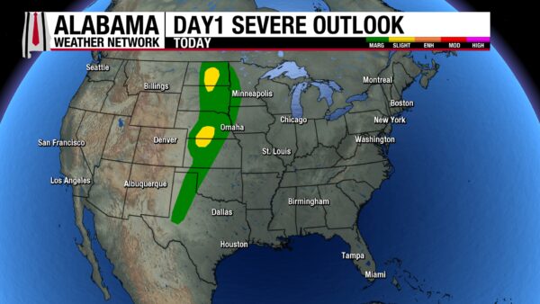
The Storm Prediction Center highlights parts of the northern and central Great Plains under a slight risk for severe thunderstorms this afternoon and evening. The most concentrated threat lies in the Dakotas, where a strengthening low-level jet and rich moisture could fuel a few rotating storms capable of producing tornadoes.
Farther south, from the Nebraska–Kansas border into the Texas Panhandle, steep lapse rates will support storms with large hail and gusty winds. While most storms are expected to be multicell in nature, some may briefly take on supercell characteristics.
Additional storms will pop in the southern High Plains and into the Mid-South, but these are expected to remain mostly isolated or pulse in nature, with only a marginal severe threat.
TROPICS QUIET COMPARED TO 2020
A tropical wave over the eastern Atlantic is producing a large but disorganized cluster of showers and storms. Dry, stable air will keep development limited in the short term, with only a 10% chance of formation in the next 48 hours. Conditions improve by mid to late week, and the system carries a 70% chance of becoming a tropical depression as it tracks west-northwest across the central Atlantic.
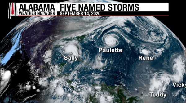
Even with this wave, today’s basin is far quieter than on this date in 2020. Five named storms were active at once that year — Sally, Paulette, Rene, Teddy, and Vicky — marking one of the most hyperactive stretches of the record-breaking 2020 season.
BEACH – BEAUTIFUL DAY ALONG THE COAST
It’s a sunny and inviting Sunday from Dauphin Island to the Florida Panhandle. Highs will top out in the upper 80s with light northeast winds shifting southeast by afternoon. Surf stays calm around 1 foot, and water temperatures hold in the lower 80s.
The rip current risk is low at all beaches, though dangerous currents can still form near piers, jetties, and reefs — always heed flags and local patrols. The UV Index is very high, so sunscreen is a must if you’re spending time on the sand or in the water.
WEATHERBRAINS EPISODE 1026
This week’s show features Melissa Marcelloni, forecaster at NWS Brownsville, TX. Melissa brings a unique perspective with her background at NCEI and in the insurance industry, where she handled major catastrophe claims across the nation. A University of Oklahoma graduate with an MBA from West Texas A&M, she’s also an avid storm chaser.
We’ll also be joined by guest panelist Chris White, who will preview the upcoming Mid-Atlantic Severe Weather Conference set for November 8 in Richmond, VA.
Watch the show Live on Monday, September 15 at 7pm CT on our YouTube Channel. Playback on Tuesday on all your fave podcast platforms.
WEATHER HISTORY
September 14, 2002: Rain, Surge, And A Brief Tornado With Hanna
Tropical Storm Hanna came ashore near the western end of Dauphin Island, Alabama, bringing a mix of wind, rain, surge, and even a brief tornado. The highest gust was clocked at 57 mph at the Pensacola Regional Airport, while Coden, AL measured a soaking 7.55 inches of rainfall. Dauphin Island recorded the peak storm tide at 3.7 feet.
In addition to the coastal flooding and heavy rains, a weak F0 tornado touched down briefly near Theodore in Mobile County, Alabama. The twister toppled several trees before dissipating, though no structural damage was reported.



