Cloud tops were cooling in the rain mass over Central Alabama. This indicates intensifying rainfall. The heaviest rain extends from Linden in Marengo County to Clanton to Columbus GA back to Montgomery and Linden.
Decaying tropical systems quite often flare up at night while over land. We will have to watch things carefully.
A flash flood watch continues for South Central and South Alabama. In addition the NWS Birmingham has just issued an Areal Flood Advisory for Autauga, Barbour, Bibb, Bullock, Chambers, Chilton, Coosa, Dallas, Elmore, Greene, Hale, Lee, Lowndes, Macon, Marengo, Montgomery, Perry, Pike, Russell, Sumter and Tallapoosa Counties till 2:45 AM CDT. This is one step short of a flash flood warning.
Rainfall amounts have been light north of I-20. A wide band of 1.5 to 2.5 inch amounts extends across South Central Alabama so far. Amounts higher than four inches are indicated on Doppler radar estimated in Russell and Barbour Counties.
Justin Gentry in Jemison reports 1.85. Other reports include: 3 inches in Hurtsboro, 4 inches in Hatchechubbee, and 2.4 at the Russell County EMA office as of 7:45 p.m. WAKA Montgomery reports 2 inches. They had a report from the public for eastern Butler County ( Midway ) of 7.25 inches.
Increasing rain activity over East Central Alabama is poised to rotate into the Birmingham Metro soon.
The center of Tropical Storm Fay was between Andalusia and Evergeen in South Alabama.
The stronger winds with the system are in the heavy rainbands to the north of the center.
SOUTH ALABAMA SURFACE OBS
Evergreen…mist…NE-7…baro 29.51 rising
Andalusia…cloudy…SE 13 G 23…baro 29.54 rising
Montgomery…ENE 35 G 44…baro 29.66 steady…visibility 1 1/2 miles in rain…0.45 inches of rain in the past 45 minutes
Troy…light rain…ENE 17 G 24…wind gust to 35 mph in past few minutes
A tornado watch continues for much of South Central and Southeast Alabama from Clanton east and south. It goes until 3 a.m.
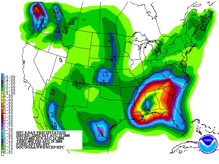
Rain will continue through Tuesday over much of Alabama. Here is the updated QPF map from the HPC in Washington. It shows the potential for some impressive rainfall amounts over the entire state of Alabama between now and Thursday night.