


RADAR CHECK: A few scattered showers and thunderstorms are over the southern half of Alabama early this morning, but they will fade quickly after sunrise. A decent part of the state will be dry today, although scattered storms will form again this afternoon mainly across the southwest corner of the state. Afternoon highs will range from the mid 80s across North Alabama to the low 90s over the southern counties.
While much of the day tomorrow will be dry, high resolution models do suggest an organized batch of showers and storms will enter the western counties late in the day. These should weaken quickly after sunset tomorrow night, and fade before they reach the eastern half of the state.
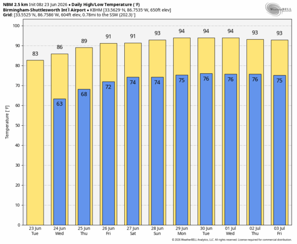
Then, showers should be few in number over the latter half of the week as an upper ridge begins to form over the eastern half of the U.S. Heat levels will rise with highs at or over 90 degrees statewide by Friday.
THE WEEKEND: Alabama’s weather will be hot and mostly dry Saturday and Sunday with just a small risk of any one community seeing a passing afternoon shower or storm. Highs will be in the low to mid 90s… it will be the hottest weekend so far this summer.
The upper ridge will stay in place next week, meaning hot and mostly dry weather for the Deep South with only isolated afternoon showers. See the video briefing for maps, graphics, and more details.
TROPICS: The Atlantic basin is calm; tropical storm formation is not expected for at least the next seven days.
ON THIS DATE IN 1944: Four tornadoes killed 153 persons and caused five million dollars damage in Pennsylvania, West Virginia and Maryland. The tornadoes formed during the evening and moved southeast along parallel paths flattening everything in their way. The town of Shinnston WV was leveled, and was left with the majority of the casualties.
Look for the next video briefing here by 3:00 this afternoon… enjoy the day!



