A significant severe weather situation is unfolding across Alabama on this Easter Sunday and al types of severe weather are possible through tonight, including large hail, damaging winds, and tornadoes, including the possibility of significant, long-track tornadoes. Let’s bring you up to speed on the latest.
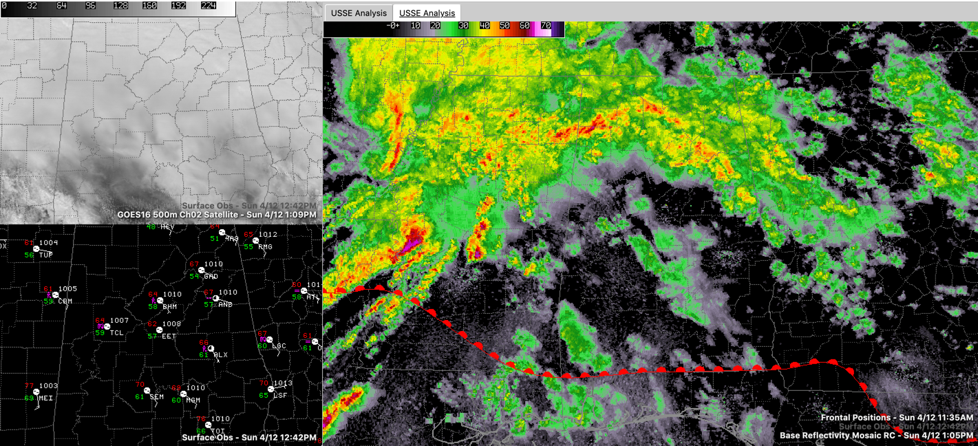
FORECAST ON TRACK: So far, everything has evolved as expected with the event. A passing disturbance triggered showers and some thunder this morning and a northward lifting warm front has pushed widespread shower and thunderstorm activity through Central and North Alabama. No severe weather in Alabama yet, but lots of heavy rain, lighting, and some small hail. That warm from is the advance guard of a warm, moist, and unstable air mass that will surge across the area for the remainder of today and tonight. The airmass will be “capped” by warmer, drier air aloft from the southwest, which will keep a bit of a lid on thunderstorm development for awhile. We are already seeing sunshine pop out over southern Mississippi and southwestern Alabama. This will allow the atmosphere to build up more instability before it boils over later this afternoon and evening.
SEVERE WEATHER TO OUR WEST: Severe thunderstorms produced large hail and tornadoes in Texas overnight. That same MCS produced significant tornado damage in Monroe, Louisiana just before noon, with other tornado reports back into northwestern Louisiana. That storm was crossing the Mississippi River as of this writing. It is ahead of a sharpening upper-level trough that will take ono a dangerous negative tilt as it pushes eastward into tonight.
PDS WATCH: Much of northern and central Mississippi has a Particularly Dangerous Situation Tornado Watch til 8 p.m. You might imagine that is the worst kind. We could see one later.
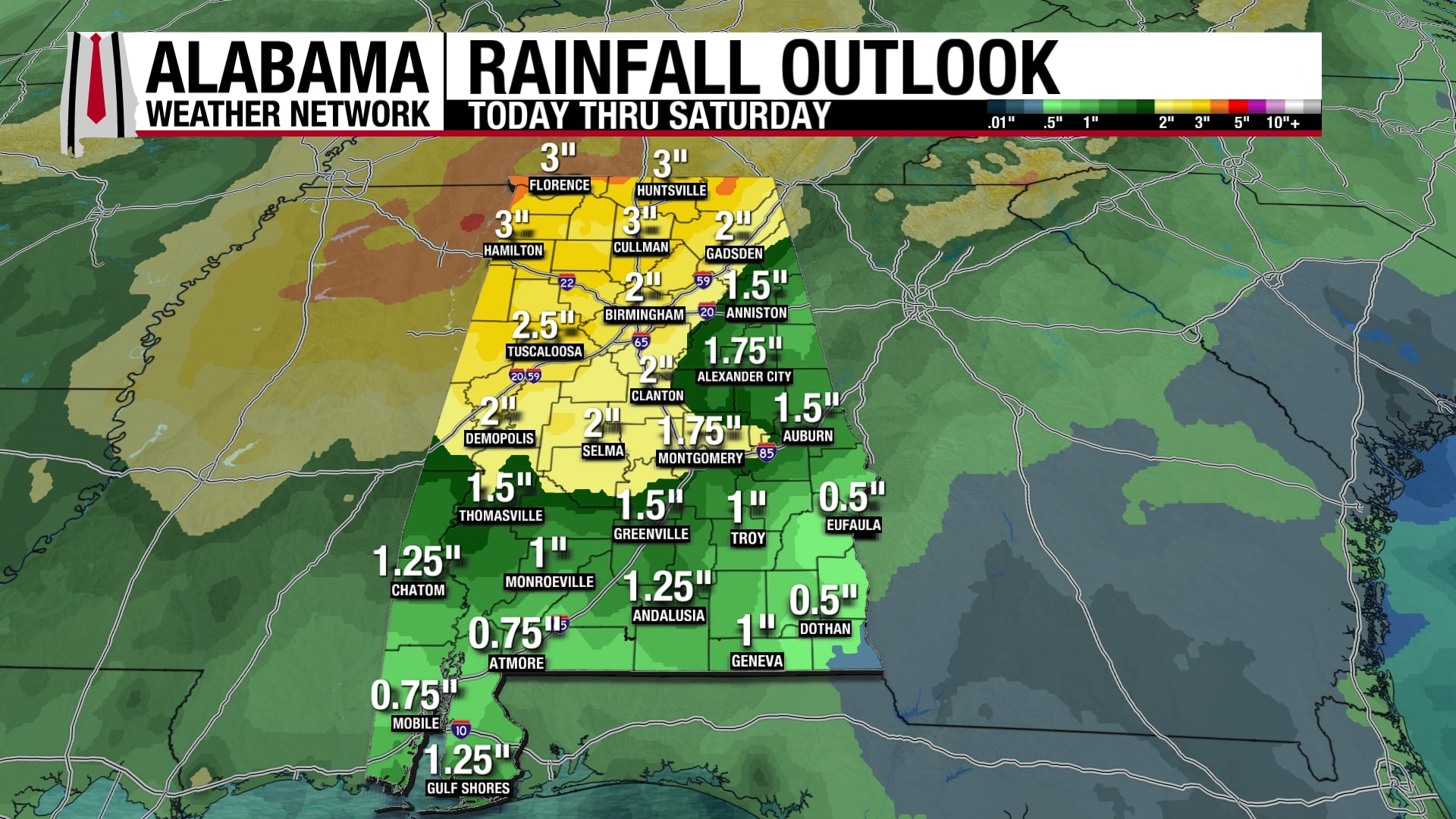
WIND ADVISORY/FLASH FLOOD WATCH: Increasing winds through the afternoon will gust to 35-40 mph at times outside of thunderstorms so wind advisories have been issued. Rainfall amounts will average one inch, but areas that see heavier convection will pick up 2-3 inches of rain in short order, and flash flood watches have been posted for North and Northwest Alabama. The combination of the rainfall and wind will bring some trees down on its own. And agencies testing tents and other temporary structures may want to consider laying them down for the event, between the non-thunderstorm winds and the potential for damaging winds later.
THE REALLY DANGEROUS PERIOD will be later this afternoon and this evening as storms form in the volatile airmass. They will quickly become severe and all hazards will be on the table with instabilities pushing as high as 2,500 joules/kg, bulk shear values around 75 knots and storm-relative helicity values near 500 m2/s2, intense, long-lived convection with the potential to produce strong tornadoes will be possible. Large hail and damaging winds will be possible as well.
LATE EVENING QLCS: A line of severe thunderstorms will move into western Alabama this evening, accompanied by tornadoes, large hail, and damaging winds. This activity should be out of western Alabama by 10 p.m., into the Birmingham area between 11 p.m. and midnight and out of East Central Alabama by 2 a.m. It could linger rover southeastern sections until 4 a.m. or so, however.
A SAFE PLACE: Refresh your emergency kit and put it in your safe place. Know where you and your family will go when a warning issued. Think lowest floor, interior room. Putting as many walls between you and the outside as possible. Refresh your emergency kit and put it in your safe place. Have hard-soled shoes, helmets, and an air horn to signal rescuers. Mobile and manufactured homes are not the places to be in a tornado or strong winds. Know where you can go to a substantial structure or community shelter well before the storm arrives.
COMMUNITY SHELTERS AND COVID-19: The pandemic means that many community shelters will not be open. Check now to see if yours will be or not. If it will, plan on going in time to arrive ahead of the storm. Don’t go in until the storm is getting close. Practice proper social distancing in the shelter. Go home and wash up once the all-clear is given. The Alabama Department of Emergency Management, the National Weather Service, and the American Meteorological Society all remind you that you must protect yourself from the more immediate threat of the tornado first and foremost.
BE A WEATHER AMBASSADOR: Pay attention to weather information throughout the event. Notify friends, families, and neighbors who may not be aware.
IMPROVING CONDITIONS: Monday will be a breezy, mild day, with clearing skies. Monday evening will be mostly clear and cool, with lows in the lower and middle 40s. Tuesday will be sunny and cooler than normal with highs in the 60s.