


It’s the first day of June, and the normal high temperature for Birmingham is 85 degrees. We will be at least 10 degrees above the norm this afternoon with highs in the middle and upper nineties! If we do make it to 95 in Birmingham, that will tie the record set back in 1953, and of course, 96 degrees (the expected high) will break the record. Forget the 90s; it will feel like it is at or above 100 degrees for most of the afternoon. By the way, the earliest record of 100º in Birmingham is June 5th. Huntsville’s earliest 100-degree day is June 3rd, and Tuscaloosa’s is June 6th. We do not expect temperature to reach that level, but it would not be surprising to see some backyard thermometer reports of 99 or 100 degrees.
There is a Heat Advisory up for northwestern Alabama (Cullman, Morgan, Madison, Limestone, Lawrence, Lauderdale, Colbert, and Franklin Counties) from the National Weather Service in Huntsville:
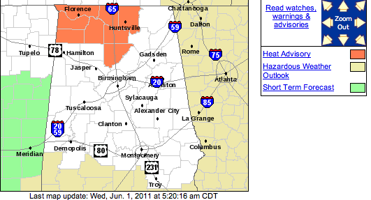
…HEAT ADVISORY IN EFFECT FROM 1 PM TO 7 PM CDT THURSDAY…
THE NATIONAL WEATHER SERVICE IN HUNTSVILLE HAS ISSUED A HEAT
ADVISORY FOR NORTHWEST AND NORTH CENTRAL ALABAMA…WHICH IS IN EFFECT
FROM 1 PM TO 7 PM CDT THURSDAY.* TIMING: A VERY STRONG HIGH PRESSURE SYSTEM CENTERED OVER THE REGION
ALONG WITH PEAK DAYTIME HEATING ON THURSDAY WILL CAUSE HEAT INDEX
VALUES TO RISE TO OR JUST ABOVE 105 DEGREES BETWEEN 1 PM AND 7 PM
CDT THURSDAY.* TEMPERATURE: VERY HOT TEMPERATURES NEAR 100 DEGREES ALONG WITH HEAT
INDICES AT OR SLIGHTLY ABOVE 105 DEGREES.* IMPACTS: THE POTENTIAL EXISTS FOR A HIGH NUMBER OF HEAT RELATED
ILLNESSES ON THURSDAY AFTERNOON DUE TO THE EARLIER THAN USUAL RISE
IN TEMPERATURES NEAR 100 DEGREES.PRECAUTIONARY/PREPAREDNESS ACTIONS…
A HEAT ADVISORY MEANS THAT A PERIOD OF HOT TEMPERATURES IS
EXPECTED. THE COMBINATION OF HOT TEMPERATURES AND HIGH HUMIDITY
WILL COMBINE TO CREATE A SITUATION IN WHICH HEAT ILLNESSES ARE
POSSIBLE. DRINK PLENTY OF FLUIDS…STAY IN AN AIR-CONDITIONED
ROOM…STAY OUT OF THE SUN…AND CHECK UP ON RELATIVES AND
NEIGHBORS.
There could be a hand full of isolated showers today and tomorrow, but there just won’t be enough of them to reduce the heat on a large scale. Expect temperatures to stay in the lower and middle 90s at least through the weekend!
-Jason
Follow me on Twitter: @simpson3340
Facebook: Jason Michael Simpson



