


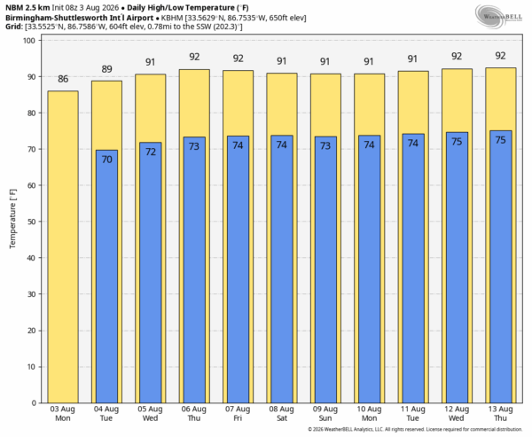
TEMPS BELOW AVERAGE: Most all of Alabama will remain under 90 degrees today, very pleasant for early August. An upper low to the east will bring the potential for a few small, isolated showers this afternoon and early tonight, mainly over the eastern half of the state.
Not much change tomorrow; the high will be in the 87-91 degree range with only isolated afternoon showers. Then, heat levels creep up over the latter half of the week with highs back in the low 90s. You always have the risk of a pop-up afternoon shower or storm every summer day in Alabama, but they will likely remain few and far between as an upper ridge begins to build over the region.
THE WEEKEND: Routine summer weather is the story; partly sunny days, highs in the low 90s, and a few widely scattered showers and storms around, mostly during the afternoon and evening hours. Chance of any one spot getting wet both days is 20-30 percent.
And, no real sign of change for at least the first half of next week. See the video briefing for maps, graphics, and more details.
TROPICS: The Atlantic basin remains very quiet, and tropical storm formation is not expected for at least the next 7-10 days.
ON THIS DATE IN 1970: Hurricane Celia made landfall near Port Aransas as a major Hurricane, Category 3 on the Saffir-Simpson scale with sustained winds of 130 mph. In Corpus Christi, about one-third of houses suffered severe damage or were destroyed. Additionally, about 90% of the buildings in downtown were damaged to some degree.
ON THIS DATE IN 1995: Hurricane Erin made landfall at Pensacola Beach with winds of 85 mph. Hurricane force-winds lashed the Florida Panhandle’s westernmost counties – Escambia, Okaloosa, and Santa Rosa – including sustained winds up to 81 mph at Hurlburt Field near Mary Esther and a wind gust up to 101 mph at Naval Air Station Pensacola.
Look for the next video briefing here by 4:00 this afternoon… enjoy the day!



