


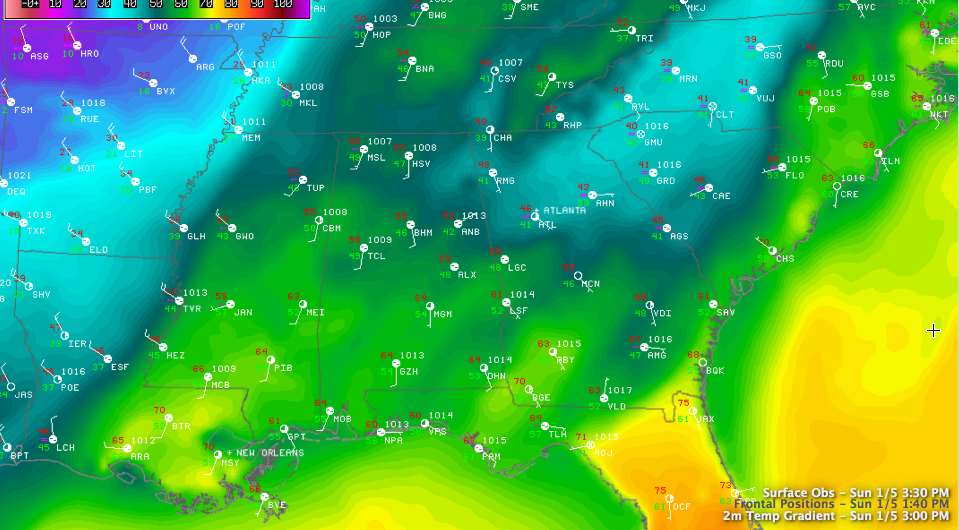
It’s not hard to find our cold front this afternoon. It has crossed over the Mississippi River in western Mississippi. It has passed Greenwood and is approaching Tupelo at this hour.
It is now about 60 miles west of Marion and Lamar Counties.
It is pushing southeast at 20-25 mph. It should arrive in Hamilton about 6:30.
Behind the front, temperatures drop off quickly. At Tunica, it was 52F at 12:45. Within two hours, the mercury had already fallen to freezing. That’s a 20 degree drop in two hours.
Radar shows a 60 mile wide band of light rain centered along the front. Light rain is occurring into western Alabama as well, from northern Tuscaloosa County through Fayette and Walker into Marion and Winston Counties. Rain should reach the Birmingham area by 6 or 7.
The front should reach Jasper and Tuscaloosa around 6:30 to 7 P.M. and Birmingham around 7:30 to 8 p.m. It should get to Gasden between 9-10 p.m. and Anniston about 30 minutes later. Temperatures will drop about 9-10 degrees in 20 minutes and the winds will shift to northwest and pick up to around 20-30 mph with gusts to 40 mph or more as the front passes.
We could see some icing on roadways as soon as they reach freezing. Remember that bridges get colder faster than surrounding roads, and icing will be a problem on bridges about 90 minutes to an hour after the front arrives if there is precipitation falling or moisture on roadways from rain. Hence the Winter Weather Advisory for tonight. The NWS has trimmed the time back to have it expire at 6 a.m. Monday morning.
The precipitation will go from rain to freezing rain to a sleet/freezing rain mix then to light snow.
The more significant precipitation should end in the Tuscaloosa area around 10 p.m. and Birmingham and Gadsden about 11 and in Anniston after midnight.
Occasional light snow will continue through the overnight, ending from west to east between 3 a.m. and 6 a.m.
If you have to travel tonight after the front passes, please check the latest weather forecasts and road conditions and prepare for the dramatic drop in temperatures. Dress appropriately.
Additional snow showers will occur occasionally during the day tomorrow as well as temperatures struggle to reach 20F. The hard freeze warning, wind chill advisory and wind advisories remain in effect for Central Alabama.



