


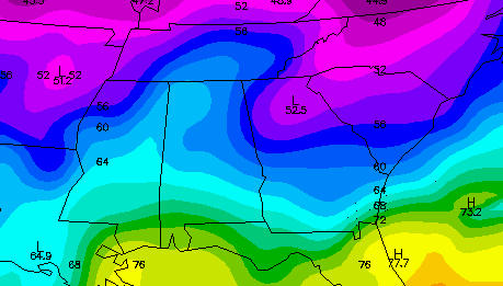
November is coming in cool, as it should. First of all, we have a fairly significant “wedge” event going on east of the Appalachians, where cold air comes pouring down east of the mountains because it is too shallow and stable to get over the mountains. You can see the cold air in North Carolina (40s at mid-morning in Mt. Airy), moving southwest around the mountains into Georgia (53 in ATL) and then Alabama. The easterly winds will keep our temperatures mainly between 55 and 60 over the next couple of days and nights, and with a low in the Gulf tomorrow, we will see a soaking rain, 1/4 to 1/2 inch over north AL and near 1″ over south AL.
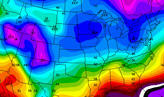
Then, there’s the larger batch of cold air to our north. Mid-morning temperaturs are in the 30s and 40s from KY, MO, and OK north this morning. A cold front will bring that larger area of cold air in here by Thursday, with highs only near 60 Thu and in the 50s Fri, Sat, and Sun. Daytime wind chills will be in the 30s and 40s Thu and Fri, so be ready for that! Overnight lows over the weekend (starting Fri night) will be in the 30s as far south as Montgomery, with lows below freezing at least one night in many areas from Clanton north.
We’ve seen this kind of pattern before, with a warmer than normal September/October. The cold air builds up in the Arctic regions (temperatures are in the 10s and 20s over Alaska, and below zero in Siberia), because so far, there have been few cold fronts to bring any of it south. However, the instability of that large of a temperature gradient and the associated jet stream (120 to 140 knots, or 135 to 160 mph) can not hold forever, and the cold air sometimes comes rushing south very quickly in November and December. The models already show another, colder air mass in 2 weeks, so we’ll see.



