A cold air mass continues to flow into Alabama early this morning. Looking at a few temperatures at 2 am, 21 in BHM and Gadsden, 27 in Tuscaloosa, 19 in Cullman, and 17 at UAH in Huntsville. The coldest temp in Alabama is 14 at a higher elevation just east of Huntsville. It is 9 degrees in Crossville, TN. Temps probably won’t drop much more, maybe another 2 or 3 degrees.
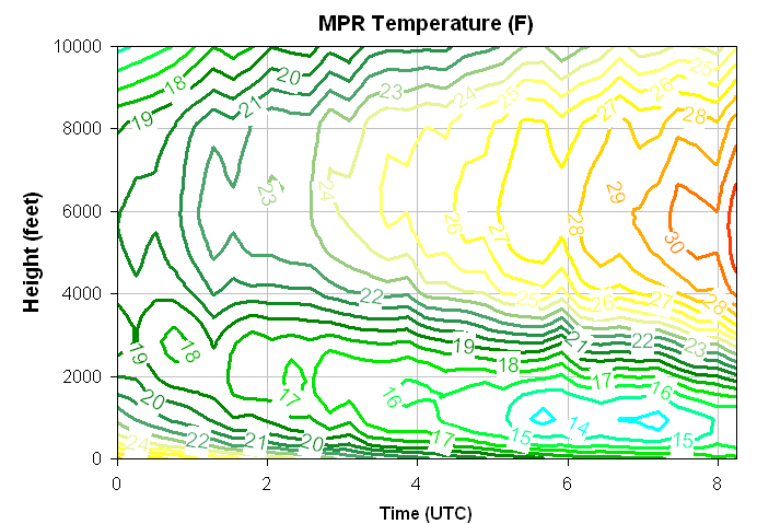
This cold air mass is very shallow. Take a look at this graph of temperature vs. time and height from the profiling radiometer at UAH over the past 8 hours (times are in UTC, and we are 6 hours behind that). Even though temps keep dropping near the surface (upper 20s at 00 UTC/6 pm, 14-17 since 06 UTC/midnight), warmer air has already started coming back in aloft. At 5000 feet, it has warmed from about 20 degrees at 6 pm to 31 degrees now.
With an overrunning situation setting up, clouds are already starting to move in from the west. Temperatures will warm up into the upper 30s to 40s today, depending on how much cloud cover moves in. But, some models (GFS, NOGAPS, UKMET) show some light precipitation reaching central Alabama tonight. With the cold, dry air at low-levels, but warmer air aloft, IF we get precipitation tonight, some of that could fall as sleet or freezing rain. The warm air aloft would prevent any snow.
Right now, it looks like precipitation amounts should be very light, so no major problems are expected with icing. But, this is something to watch today.