


Daily Weather Briefing
Saturday, February 7, 2026

ALABAMA THIS MORNING
Skies are clear this morning, and winds are gusting in the single to mid-teens in the north to the upper teens and low 20s south. Temperatures are chilly, sitting in the low 30s north, mid 30s in central Alabama, and low 40s in the south. The coast has breached the upper 40s and even hit 50 degrees.
Our Hoover Skycam captures the radiant sun rising over a beautiful, chilly Saturday morning.

The Skywatchers are observing temperatures in the 30s on this clear Saturday morning. The cam behind the graphic is from Cullman, which currently displays a bright blue sky!
ALABAMA 7 DAY FORECAST
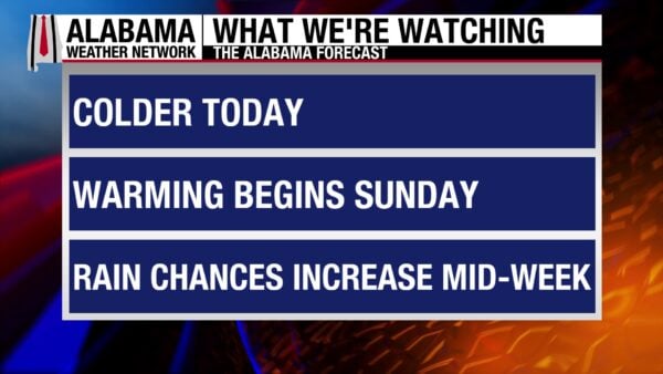
Today will be the last chilly day for the next few days. Winds will still be breezy, but weaker compared to yesterday. Tomorrow begins a warm stretch that will last through midweek. An upper-level shortwave will increase rain chances in the north starting Tuesday night and continue through Wednesday into the south. A few thunderstorms could occur, but instability will remain limited, and rain accumulation will be light. Low rain chances linger Thursday, then a wetter system moves into the area on Friday.
CHILLIEST DAY OF THE NEXT SEVEN
A dry cold front tracked through the state last night, bringing colder temperatures to the region. Highs will only reach the mid to upper 40s north, low to mid 50s centrally, and upper 50s and low 60s in the south. Skies will be clear, and winds will gust from 15-20 mph at times, especially before mid-afternoon. This will keep temperatures feeling a few degrees below the actual temperature.
LAST NIGHT OF COLD
Winds will weaken through the afternoon into tonight, and cloudless skies will persist. This will encourage radiational cooling through the night, making lows fall to the mid to upper 20s for the northern half of Alabama, and the low 30s in the southern half. The coast will stay in the upper 30s.
SUNDAY BRINGS SPRING
Upper-level ridging will quickly move into the region Sunday. Clear skies and highs reaching the upper 50s north, and low to mid 60s heading south will bring a taste of spring to the state. Winds will be light.
WARMING MONDAY AND TUESDAY
Highs Monday will shoot up to the upper 60s in the northern half of the state and the low 70s in the southern half. Some high clouds may form in response to the air being moister. Tuesday will see the 70s creep further north, with only the most northern part of Alabama staying in the upper 60s. Clouds will increase as an upper-level low inches toward the state, and moist ait gets closer. Rain chances increase in north Alabama to a low 20% Tuesday night.
LIGHT SHOWERS WEDNESDAY AND THURSDAY
Light showers will traverse through the state Wednesday and Thursday. A few thunderstorms may develop, but instability is limited and severe weather is not expected. Highs Wednesday will be slightly cooler in the north but warmer south. The north will stay in the mid to upper 60s, while central and south Alabama will range from the low to mid 70s! Cooler Thursday highs will range from the upper 50s to lower 60s north, mid to upper 60s centrally, and upper 60s to low 70s in the south.
FRIDAY RAIN
Another system will bring rain chances to the state, and they will be slightly higher than the previous days’. Highs fall back to the cooler side, spanning from the upper 40s north to the upper 50s south.
LITTLE CHANGE TO DROUGHT CONDITIONS
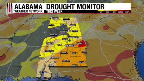
Drought conditions have changed very little over the past week. There has been a slight increase in how much of the state is drought free, changing from 14.88% to 15.01%. Less of the state is experiencing Moderate (D1) and Severe (D2) Drought, with both categories seeing less than a 1% decrease. 22.86% of the state is in D1 and 23.60% is in D2. Parts of Lee, Russell, and Macon counties remain under Extreme Drought (D3) conditions, but the category has not changed since last week. A few more areas experience Abnormally Dry (D0) conditions due to the decrease in D1 and D2. 36.90% of the state sits in the D0 category.
TODAY IN WEATHER HISTORY
February 7, 1812- The Final Major Quake in Madrid Earthquake Series
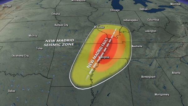
On February 7th, 1812, The Hard Shock Earthquake struck the area around the small farming community of New Madrid, Missouri. It was the last three strong earthquakes that occurred in the New Madrid area from 1811-1812. The quake was estimated to be a 7.5-7.7 on the Richter scale. This is the strongest earthquake on the eastern side of the Rockies! Destruction ensued in the area. Chimneys crumbled; the ground sank, lifted, and warped; landslides occurred; and water banks caved. Lake St. Francis in Arkansas, formed by the previous earthquakes, expanded further. Observations came in that the Mississippi River’s flow was suddenly reversed. Although it did not actually reverse, the quake caused northward moving water that gave the illusion of a reversed river. Reelfoot Lake, in what is now Tiptonville, Tennessee, was created due to uplifting of land. These earthquakes were in the New Madrid Seismic Zone (NMSZ), which spans from northeastern Arkansas/northwestern Tennessee to southeastern Missouri/southwestern Kentucky. Thousands of aftershocks were reported throughout the 1811-1812 period, and for years after. The 150-mile-long fault is still active today, and Memphis, Kansas City, and St. Louis sit in the area. Another earthquake could cause a lot of damage, even if it was not as strong as the main three.

IMAGE OF THE DAY
Today’s Image of the Day comes from Mobile’s Mardi Gras Parade last night, captured by our Mobile Skycam!



