


Sunday, November 9, 2025
Forecaster: Bill Murray
Freeze warnings cover much of North and Central Alabama for Sunday night as temperatures fall into the mid and upper 20s across most of the region. Readings will be even colder Monday night. Now is the time to protect people, pets, pipes, and plants. Keep fire safety rules in mind, especially with space heaters, which can be dangerous if used improperly.
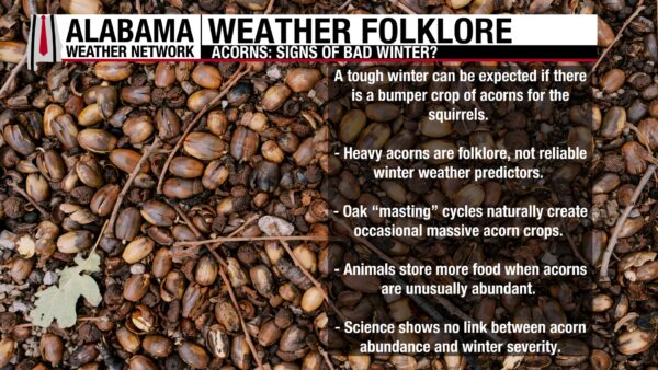
DO HEAVY ACORN FALLS MEAN TOUGH WINTER?
Folklore suggests that a bumper crop of acorns signals a harsh winter ahead. This is fiction, not fact. Oak trees produce heavy acorn crops in natural cycles called “mast years,” which occur every few years. The amount of acorns has no connection to upcoming winter weather.

Social media provided this gorgeous photo of the last persimmon harvest of the year from Quynh Nga, sent to @spann. We appreciate all of our social media contributors!
ALABAMA 7 DAY FORECAST
A powerful arctic front is moving across Alabama this morning, bringing sharply falling temperatures, strong northwest winds, and the first true winter chill by tonight.
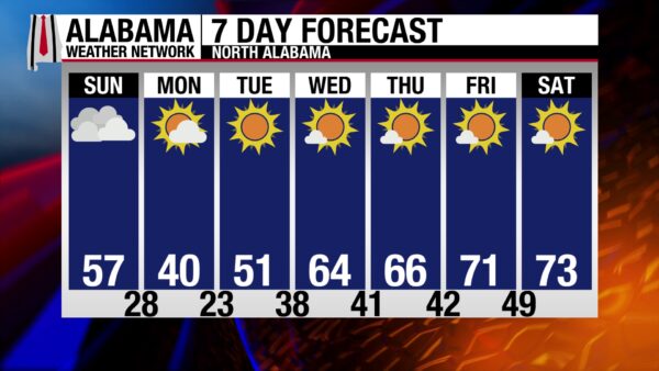
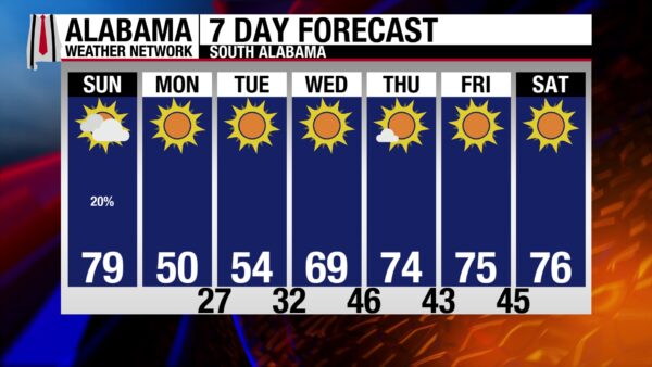
FRONT IS MOVING THROUGH WITH FALLING TEMPERATURES
Light rain is forming along the front as it moves southeast between sunrise and midday. Temperatures start in the 60s and lower 70s but drop steadily this afternoon, falling into the 40s north and 50s across central and south Alabama by sunset. Northwest winds increase to 20–30 mph statewide, strongest in the Tennessee Valley. Skies clear quickly behind the front as drier, colder air arrives.
TONIGHT TURNS SHARPLY COLDER WITH A HARD FREEZE
Temperatures plunge after sunset as arctic air spreads in. Lows fall into the mid 20s north, upper 20s to near 30 central, and lower 30s south, bringing a freeze to nearly the entire state. Wind chills drop into the teens and 20s while breezy northwest winds continue into late evening. A few flurries are possible near the Alabama–Tennessee border on the higher terrain, but no travel impacts are expected.
MONDAY IS COLD AND WINDY FROM START TO FINISH
Monday begins with wind chills in the teens north and widespread 20s elsewhere. Highs only reach the upper 30s to lower 40s in North Alabama, lower to mid 40s across Central Alabama, and upper 40s in the south. Northwest winds gusting 20–30 mph keep the day feeling sharply colder. Fire danger is elevated across southern Alabama where dry air and gusty winds overlap.
TUESDAY THROUGH THURSDAY START COLD, THEN MODERATE
Another freeze arrives Tuesday morning with lows in the 20s statewide except for immediate coastal communities. Sunshine and lighter winds help temperatures rebound into the 50s north and lower 60s central and south. A gradual warming trend follows Wednesday and Thursday as winds shift more westerly, bringing highs back into the 60s to near 70 and lows into the upper 30s and 40s. The period stays dry statewide.
FRIDAY AND SATURDAY TURN MILDER AND REMAIN DRY
Milder air builds in to end the week. Highs reach the upper 60s to lower 70s on Friday and rise slightly on Saturday. Overnight lows settle in the 40s and lower 50s. Alabama stays dry through Day 7, and drought conditions continue.

SATURDAY EXTREMES
National High/Low temperatures for Saturday, November 8, 2025: 99 at 2 miles north-northeast of La Puerta, TX; 5 at 20 miles west-southwest of Dubois, WY.

COLD AIR SURGES SOUTH
A strong push of polar air is racing south through the Central U.S. today, delivering the coldest temperatures of the season to the Plains and setting up a major pattern flip by Monday. This sharp blast of arctic air continues driving southeastward, reaching the Deep South by early Monday and spreading freezing temperatures far beyond their typical November reach. The temperature contrast between the cold interior and the still-mild East Coast is strengthening a developing low-pressure system sweeping across the central and eastern states.
MIDWEST, GREAT LAKES SNOWS
Snowy, windy, and bitterly cold conditions take hold from the Northern Plains through the Upper Midwest and into the Great Lakes as the weekend progresses. A band of accumulating snow moves into lower Michigan today, with colder air changing rain to snow around the lower Great Lakes by Monday. Gusty west winds and falling temperatures could briefly enhance snowfall near Lake Michigan, including around Chicago, where a small-scale low may form over the warmer lake waters. Snow showers also reach the central Appalachians late Monday on strong northwest flow.
CRASHING TEMPS
Ahead of the polar front, the South and East Coast enjoy one last mild day with temperatures climbing near 70 as far north as Washington, D.C. Passing thunderstorms develop from the Mid-Atlantic into southern New England, especially Sunday evening into the overnight hours. A strong cold front sweeps offshore late Sunday night, replacing the warmth with sharply falling temperatures and strengthening west winds. Freezing temperatures spread deep into the South by Monday.
WESTERN WARMTH
The western U.S. warms under a strengthening upper ridge extending from the Southwest into the northern High Plains. Temperatures rise well above seasonal averages, contrasting sharply with the arctic chill gripping the central and eastern states. The Pacific Northwest becomes unsettled late Monday as the next Pacific system arrives with light rain and increasing clouds.
FIRE WEATHER
Critical fire weather conditions develop in southern Texas today as strong post-frontal winds combine with very low humidity and dry fuels. The Storm Prediction Center highlights the region for elevated to critical fire danger. The combination of gusty winds, dry air, and ongoing drought makes conditions favorable for rapid fire spread.
COOL CHANGE HEADING FOR THE BEACHES
It’s a picture-perfect day along the Alabama and Northwest Florida beaches with sunshine, light west winds, and 1–2 foot surf from Dauphin Island to Destin. Water temperatures hover near 70 degrees and rip current risk remains low. Sunday brings one more mild, mostly sunny day, though a slight chance of a shower pops up closer to the Florida beaches as northwest winds increase. By Sunday night, much colder air arrives with stronger north winds and surf rising to 2–3 feet. Monday feels dramatically colder with highs only in the 50s under bright sun and a brisk north wind.
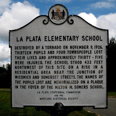
TODAY IN WEATHER HISTORY
On November 9, 1926, a violent F4 tornado tore through La Plata, Maryland, producing the deadliest toll from a single tornado in state history. The storm destroyed a school, hurling the building into a grove of trees and killing 13 students. Four more residents died and over 60 were injured. The tornado traveled 18 miles from La Plata to Cedarville, scattering debris extraordinary distances—desks were carried seven miles, papers were found 36 miles away in Bowie, and debris turned up nearly 50 miles from town. La Plata would face tragedy again in 2002 when another F4 tornado struck, making it the only community in Maryland hit twice by tornadoes of such intensity.
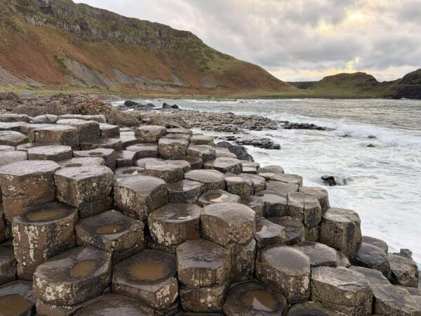
IMAGE OF THE DAY
Tracey Carroll Powers sent in this photo of the Causeway of the Giants in Ireland via social media to @spann on Friday.



