


Daily Weather Briefing
January 4, 2026
ALABAMA YESTERDAY
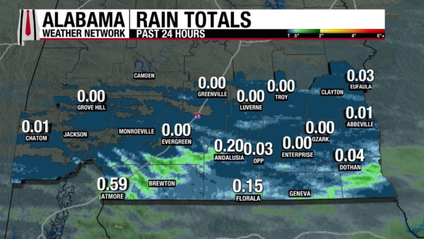
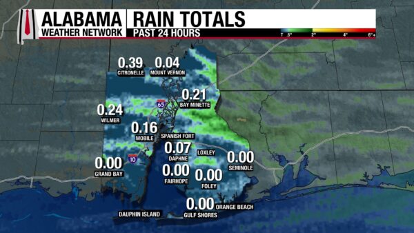
Yesterday’s weather story must again be told in two parts. North and central Alabama remained dry under mostly cloudy skies. Highs ranged from the upper 50s to the low 60s. Scattered showers and thunderstorms affected south Alabama through the morning and afternoon. A few storms were strong enough to produce Severe Thunderstorm Warnings in counties such as Baldwin and Houston. Highs reached the mid to upper 70s, which was considerably warmer than areas farther north. Rain moved out of the state by the evening, while clouds lingered. Rainfall amounts were low, ranging from 0 to less than 0.4 inches.
ALABAMA THIS MORNING
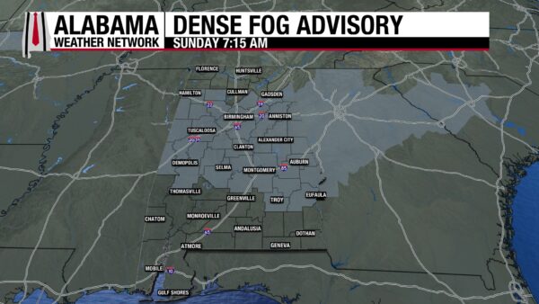
Fog envelops much of the state this morning, with a Dense Fog Advisory in effect for central Alabama until 8 AM. Skies are clear to the north, and patchy fog and clouds cover the south. Temperatures are in the mid 30s north, upper 30s to 40s centrally, and upper 40s to low 50s south.
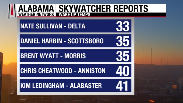
SPANN’S SKYWATCHERS
The Skywatchers are reporting temperatures in the low 30s to low 40s this morning.
Join the team! Learn how to become a Spann Skywatcher: https://www.spannskywatchers.com/
ALABAMA WEATHER
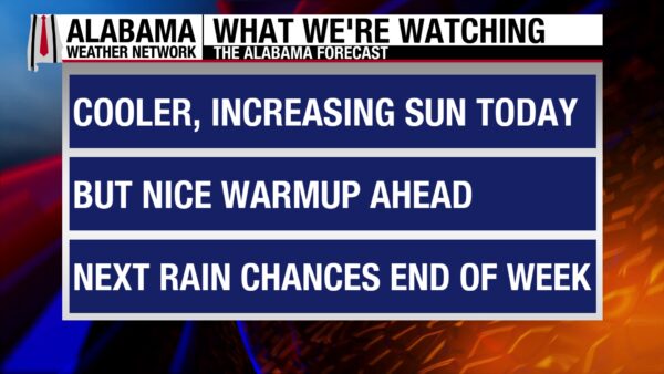
Today will likely be the coolest day of the week. A warming trend is set to begin for the first full week of January, bringing high temperatures above average through Friday. The state will remain rain-free through the first of the week before a low-pressure system brings rain and thunderstorm chances back into the forecast Thursday and Friday.
MOSTLY CLEAR, COOL SUNDAY
Clouds and fog will dissipate throughout the day except for southeast Alabama. Highs in north Alabama will top out at the mid to upper 50s, while central and south Alabama climb to the 60s.
FOGGY NIGHT
Fog will once again form in the state overnight, bringing a chance for another Dense Fog Advisory to be issued. Cloud cover will inch into the state from the south. Lows will fall to the upper 30s north and mid to upper 40s farther south.
WARMING THROUGH WEDNESDAY
The weather pattern through Wednesday will be mostly sunny skies and warm high temperatures. Highs Monday will reach the mid 60s to around 70. On Tuesday, highs increase to the 70s across the state. Wednesday will be similar.
RAIN CREEPS IN THURSDAY
Rain chances increase slightly on Thursday ahead of a low-pressure system. Highs will be in the 70s across the state.
SHOWERS AND THUNDERSTORMS FRIDAY
The low-pressure system will track north of Alabama Friday, bringing higher rain and thunderstorm chances to the state. It is still too early to know if the storms will become severe, but it is an environment we will continue to watch over the week. Highs will be in the 60s and 70s once again.
SLIGHT COOL DOWN SATURDAY
Behind the system and its cold front, temperatures Saturday will climb into the low 50s and low 60s.
RECORD SNOWFALL IN MICHIGAN
Sault Saint Marie recorded a daily maximum snowfall amount of 6.2 inches yesterday. This breaks the 1957 record of 5.4 inches.
WET WEST COAST
Heavy rainfall will continue over the California coast and central valleys today through tomorrow. Flash flooding is possible in these areas, with the upslope areas of the northern Sierra under a Slight Risk (2/4) for Excessive Rainfall.
Moderate to heavy rainfall will impact the Pacific Northwest today as well, although flash flood risk is lower.
Heavy snow falls in the higher elevations of mountain ranges of the West, with the Sierras forecast to receive a foot of snow. The Cascades, Great Basin, and northern Rockies will see locally heavy snowfall as well.
WINTERY WEATHER NORTH
A clipper-like system is forecast to make its way through the Great Lakes and Northeast tonight, producing 4-6 inches of snow in the Great Lakes and low accumulations of freezing rain in the Upper Midwest.
Upstate New York and New England will receive snow showers Monday as the system continues east, but accumulation amounts will be small.
Another round of freezing rain is expected in the Upper Midwest and Great Lakes Monday and Tuesday as another system enters the area. The potential for more significant accumulation is present Tuesday.
NATIONAL HIGH AND LOW
McAllen, Texas, not only hit the national high, but it also tied its high temperature record yesterday! 94 degrees was recorded, tying the record observed in 1971. Mount Washington, New Hampshire, has recorded the national low frequently recently, and did it again yesterday! A low of –12 degrees was reached.
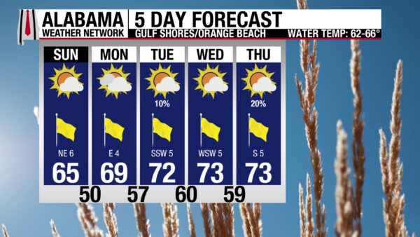
GOOD BEACH WEATHER AHEAD
After rough water and some clouds yesterday, the upcoming beach weather pattern is more than welcome. Today, highs will be in the mid 60s, skies will be mostly sunny, and water temperatures will be in the low 60s. The risk for rip currents is low, and surf height is around 2-3 feet. Warmer high temperatures and continued calm waters are expected through most of the week.

WEATHERBRAINS 1042:
The first WeatherBrains episode of 2026 features recently retired NOAA meteorologist Peter Wolf. Wolf and the team will discuss Threat Confirmation and TV meteorologists’ role during severe weather. The episode will air tomorrow, January 5th!
HISTORY
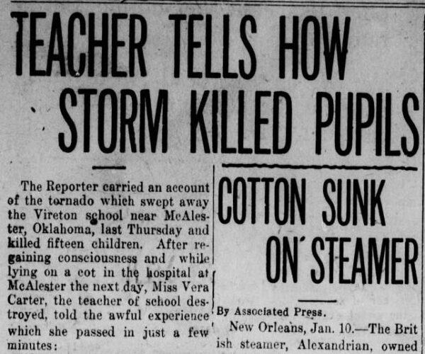
January 4, 1917 – The Vireton School Tornado
On January 4, 1917, one of the deadliest school tornado disasters in U.S. history unfolded at the Choctaw Indian Baptist Mission school near Vireton, Oklahoma, about 13 miles northeast of McAlester. After damaging structures in Richville, the F3 tornado abruptly changed course and struck the school just as the children were being released early. The small, poorly constructed building offered little resistance—it was torn from its foundation and blown apart instantly. Sixteen people were killed and ten others injured, with several victims hurled up to 100 yards across a ravine. Only two of the 29 people inside escaped injury. Debris from the school was found more than 200 yards away. The tragedy remains the fourth worst school tornado disaster in U.S. history.



IMAGE(S) OF THE DAY
Skywatchers Sandra Kirkwood, Vanessa Sanchez, and Daniel Harbin (photos ordered respectively) sent in photos of last night’s rare astronomical phenomenon. The sky featured a Super Wolf Moon, Jupiter, and stars Castor, Pollux, and Procyon. The moon was called a “Super Wolf Moon” because:
1. It was a supermoon. This means the moon was at the point of its orbit that is closest to the Earth.
2. January full moons are called “Wolf Moons”. One belief as to why is that wolves were more easily heard in mid-winter.



