


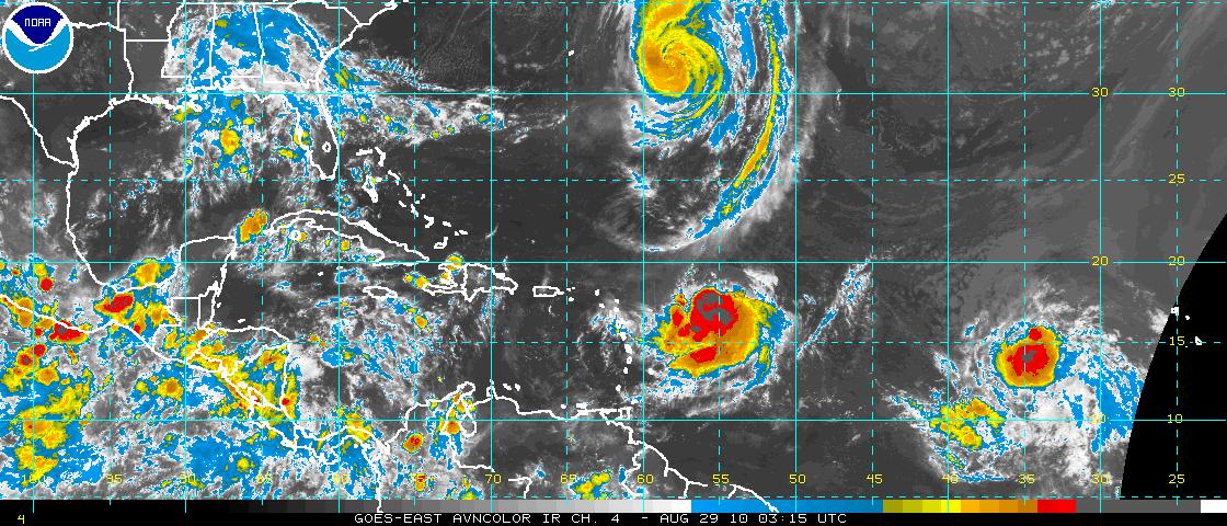
No, they are not the stars of the latest romantic comedy from Universal. They are our current tropical headliners, playing the North Atlantic.
Hurricane Danielle passed well east of Bermuda tonight and is curving out to sea, courtesy of a nice weakness in the ridge of high pressure over the North Atlantic. Dani has weakened to 105 mph now. Hopefully, the door will not close before our next system, now Tropical Storm Earl, makes his exit through the same doorway.
But Earl is threatening the northern Leewards. The storm is less than 300 miles east of the islands now. It will become a hurricane on Sunday and pass very close to the northernmost islands overnight. Hurricane force winds will affect some of the Leeward Islands late tonight. Tropical storm warnings, hurricane watches and hurricane warnings are in effect as far west as the U.S. Virgin Islands and Puerto Rico.
It appears that earl will already be making the turn to the northwest as it deals a glancing blow to the islands. By Wednesday, it should become a major hurricane and by Thursday morning, find itself midway between Jacksonville, FL and Bermuda. menacing the Carolinas. the eventual threat to the mid-Atlantic or Northeast is outside the time constraints of the current NHC forecast, but my gut feeling is that Earl will curve out to sea like Danielle. But it will make for some nervous moments along the East Coast in the week ahead.
DISTURBANCE 97L: The system over the eastern Atlantic has shown a dramatic increase in convection and a tropical depression will likely have formed by morning. It should intensify like its predecessors Danielle and Earl and be named Fiona later today. Will it threaten the East Coast? Looks like it might, but hopefully it will recurve out to sea as well. It will be an interesting week leading up to Labor Day.



