He is a big guy. He is tough and he is making huge waves as he continues to plow westward across the Caribbean. He is scheduled for a head-on collision with the Yucatan Peninsula.
The National Hurricane Center had some communication problems this afternoon from the Air Force reconnaissance aircraft. The official status of Dean is being maintained at Category 4 on the 4:00 p.m. CDT Advisory.
However, Dean is getting into an area of very warm, untapped waters over the NW Caribbean. There is an excellent chance that Dean will be upgraded to a Category 5 before making landfall. Here we go with some specific details:
LOCATION/MOVEMENT
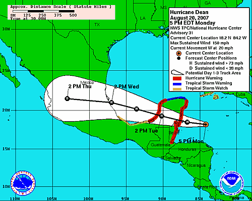
At 4:00 p.m., the center was near latitude 18.2N, longitude 84.2W or about 270 miles east of Chetumal, Mexico. Dean was moving west about 20 mph. For the next 24 hours, the track is expected to be toward the west or WNW. If this holds true, Dean should make landfall on the Yucatan Peninsula very early Tuesday morning. The weather will go downhill, however, much quicker than landfall.
WINDS/PRESSURE
Highest sustained winds were still near 150 mph with higher gusts. This makes him an extremely dangerous Category 4 and the NHC uses the word “likely” when they mention that he may become a Category 5 before making landfall. The lowest central pressure, as reported by an Air Force Reserve aircraft, was 918mb or 27.11 inches.
RAIN EVENTS
He should produce a total of 5-10 inches over the Yucatan Peninsula, Belize, Guatemala and Northern Honduras. There could be some maximum amounts up to 20 inches in all these areas. We all know that this could cause life-threatening flash floods and mud slides. Storm surge flooding of 12-18 feet above normal tide level is possible near and north of where Dean makes landfall along the east coast of the Yucatan Peninsula. This will occur along with large and dangerous battering waves. Those often cause more damage than the wind.
WARNINGS
All warnings have been discontinued for the Cayman Islands. A Tropical Storm Watch is in effect for several Cuban provinces, but all other watches and warnings in Cuba are discontinued. A Hurricane Warning remains in effect for the entire coastline of Belize, along the east coast of the Yucatan Peninsula from the Belize/Mexico border north to Cancun and along the west coast of the Yucatan Peninsula from south of Progresso southward to Ciudad del Carmen.
OTHER NOTES
Scan down to see the latest track forecast and you can see that the NHC still thinks the USA will be spared. The second landfall will be on the coast of Mexico after crossing the Bay of Campeche. As this event continues to unfold, you will see a lot of updates on this blog, including some spot reports.
ALABAMA IMPACTS
We should be spared also, however there is a possibility that a High Surf Advisory may be needed along the Alabama coast according to the National Weather Service in Mobile. They also mentioned the possibility of a Moderate to High Risk of rip currents.