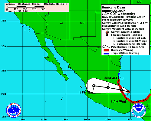
Yep, we are still dealing with Hurricane Dean today, but he is in a different ocean, but now slowly growing stronger. Here is the basic information:
LOCATION/MOVEMENT
The latest Advisory places the center of Dean near latitude 20.5N, longitude 95.5W which is about 100 miles NNE of Veracruz and about 120 miles ESE of Tuxpan. Both of those cities are on the east coast of Mexico. When Dean slid off of the Yucatan Peninsula, he moved into the Bay of Campeche, which is also the extreme SW Gulf of Mexico. He was over rather shallow waters. That part of the Gulf is known as the Campeche Bank and where Dean travelled. It was about 100 fathoms deep at first. He is now over Gulf waters that are close to 1,400 fathoms deep. Dean was moving toward the WNW at 20 mph. This is expected to continue for the next 24 hours and should bring the center of Dean across the Mexican Gulf Coast this afternoon.
WINDS/PRESSURE
Highest sustained winds have increased to near 90 mph with higher gusts. He is still a Category 1. Some strengthening will probably occur before he moves on shore. Hurricane-force winds extend outward up to 70 miles. The latest central pressure, as obtained by an Air Force hurricane hunter, was 976mb or 28.82 inches.
RAIN AMOUNTS/FLOODING
Storm surge flooding 6-8 feet above the average tide level is possible, along with large and dangerous battering waves near and to the north of where Dean makes landfall. These battering waves should never be underestimated. They can cause a big bunch of property damage along the immediate coastal area. Dean can still produce 5-10 inches of rain over part of Southern and Central Mexico, with some places getting a storm total of 20 inches. This could cause life-threatening flash floods and mudslides.
THE FUTURE OF DEAN AFTER MOVING ON SHORE
The latest track forecast continues to take the center toward the WNW (actually a little closer to west than WNW) across Mexico with the center showing up as a tropical depression after getting inland and for the rest of his trek. Interestingly enough, by Thursday afternoon the track forecast shows the center (the remnants) within about 100 miles of the Pacific Ocean. I don’t want to speculate beyond that.
DEAN AS A TROPICAL DEPRESSION
The adventurous Dean will fairly quickly be demoted to a tropical storm after moving inland and then to a tropical depression. Don’t ever underestimate a tropical depression. One of those gave Houston about 36 inches of rain a few years ago and Alberto, after being downgraded to a TD, caused massive flooding over SW Georgia and SE Alabama as he tried to make his way back to his natural habitat, the Gulf of Mexico. I don’t remember what year at the moment.
As Dean fights his way westward across Mexico, he will encounter the Sierra Madre Mountains. Some of the elevations along his path will be close to 10,000 feet. This could cause buckets of rain to be milked from Dean, especially on the east-facing slopes.
Dean has had a long, interesting life, from his very beginning in the Sahara Desert all the way to almost Mexico.
Here’s the latest tracking map.