


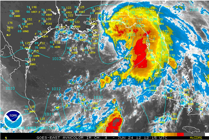
DEBBY A LITTLE STRONGER, WIND FIELD BIGGER: So the National Hurricane Center did what they needed to do and issued a tropical storm warning from the Alabama/Mississippi border to the Ochlockone River in Florida. This includes Mobile and Baldwin Counties and all the coastal counties in Northwest Florida over through Panama City and Apalachicola to south of Tallahassee. There is a chance of tropical storm force winds (39 mph or greater in the TS warning area. The area of tropical storm force winds extends 175 miles out in the northeast side of the storm, so there could be a few winds to 40 mph in the tropical storm warning area.
FORECAST TRACK THINKING UNCHANGED? No change in the forecast thinking on the track. Yet. Expecting a westward turn today, but the forecast is not high confidence and track adjustments to the north and east may be required. Stay tuned. Read down for more impacts from Debby.
DEBBY FORECAST MOTION: Still lots of uncertainty in the forecast with the models spread all over the board from Texas to Tampa. But the forecasters at the National Hurricane Center are the best in the business, so they know best. They currently call for Debby to turn westward, reaching a point 140 miles south of the mouth of Mobile Bay early Monday morning (7 a.m.). Then Debby will steam westward just south of the Louisiana coast through Thursday. This track is certainly not carved in stone.
FORECAST INTENSITY: Debby is officially forecast to become a hurricane on Tuesday night now, but I wouldn’t be surprised to see that happen sooner. The official forecast peaks it at 80 mph as it tracks south of the Louisiana coast.
IMPACTS ON GULF COAST WEATHER:
WIND: Winds will be out of the east along the Gulf Coast today, averaging 10-20 mph from Mobile to Destin and 15-25 mph with possible gusts to 40 mph east of Destin to Panama City. The wind will not be a serious problem except for boaters, who should be in port anyway.
SUN: Skies are mostly cloudy along the Gulf Coast now from Mobile to Panama City. There won’t be many breaks in the clouds today, although a few will start appearing tomorrow.
RAIN: Winds will run Rainfall amounts from the storm will average about an inch along the immediate coast.
TIDES: Tides will run 2-3 feet above normal from Mobile to Destin and 2-4 feet east of Destin to Panama City. Tides in Apalachee Bay may run 3-5 feet above normal. This will result in coastal flooding which could inundate some low lying areas like the western end of Dauphin Island, the Mobile Causeway and the road to Fort Pickens in Pensacola.
HIGH SURF: Waves will build to 5-7 feet, which will lead to erosion and will cause severe rip currents. Bodysurffing will not be recommended along the beautiful beaches of Alabama and Northwest Florida through Monday. In fact, Baldwin County beaches are reportedly closed on Sunday.
WATERSPOUTS/TORNADOES: As Debby moves westward, the northeast quadrant of the storm will be the favored place for the possible development of tornadoes and waterspouts. That means Destin to Panama City today and westward to the Alabama coast tonight.
SHOULD YOU CHANGE PLANS? If you are heading to the Gulf Coast of Alabama or Mississippi this week, I would not change my plans. Just know that the ocean will be dangerous and should be avoided at all costs. It will rain and it will be windy at times. But things should start to improve tomorrow as the westward turn takes Debby along the coast. Just keep a very close ear to the latest advisories and information on Tropical Storm Debbie. She could change her mind on a moment’s notice.
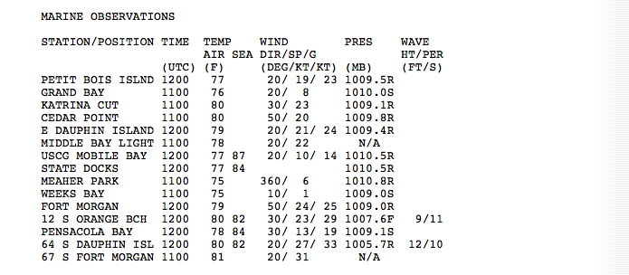
COASTAL OBSERVATIONS
Destin…cloudy…78F…NE 12 G 23…pressure 29.78
Naval Air Station Pensacola…cloudy…78F…NE 9 G 22…pressure 29.81
Gulf Shores…cloudy…77F…NE 12 G 18…pressure 29.81
IMPACTS ON CENTRAL ALABAMA WEATHER: Unless something radically changes, Debby should have little direct impact on Central Alabama weather. We may see a few showers and storms this afternoon again in areas east of I-65 and south of I-20 on the northern fringe of the circulation. We could see an increase in moisture later in the week if the remnants of the system get to come back to the northeast.



