


The models continue to have difficulty forecasting Fay’s track and intensity. The 18 UTC models have shfted back to the west.
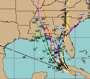
Clearly, as I said on Friday, no one, including those of us who have spent many years in meteorology, can tell right now where this storm will wind up. The tracks seem to shift every day, sometimes more than once. This storm is still not that well organized yet. And, interactions with land often change the track. It will be very interesting to see the direction of movement once it comes off Cuba tomorrow. Also, some models show a ridge building down the east coast this week, as has been typical during this summer with a seemingly unusual number of cool periods.
We are still discussing deployment locations at UAH. We had planned for Jacksonville, and that is still the current plan, but if the 00 and 12 UTC model runs continue, my original choice of Ebro, FL may work out. If it does, that was a good guess. It would be much better for Gulf Coast if the westerlies in the Gulf now push this thing on into FL…who needs rain. And, this would not allow much time for strengthening.
Nevertheless, anyone with interests along the Gulf Coast from Biloxi to Tampa should be watching this storm very carefully.



