


RADAR CHECK: Patchy light rain lingers this afternoon across parts of Southeast and East-Central Alabama, where temperatures are only in the 60s because of clouds and showers. The rest of the state is mostly sunny with temperatures in the 70s.
Showers will end across South Alabama after sunset.

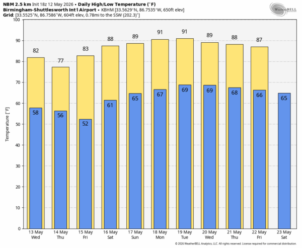
A cold front will pass through the state tomorrow in mostly dry fashion; just a small risk of a shower during the mid to late afternoon. Thursday and Friday will be dry with a good supply of sunshine both days.
THE WEEKEND: Dry weather continues, and heat levels rise. Expect a high Saturday between 87 and 91, and most of Alabama will see a high near 90 degrees Sunday… it will be the hottest day so far this year.
Next week will look and feel like summer with afternoon highs generally in the 88-92 degree range. And, like summer days, we will some risk of “scattered, mostly afternoon and evening showers and thunderstorms” on daily basis. See the video briefing for maps, graphics, and more details.
ON THIS DATE IN 1959: An F3 tornado touched down just south of Bessemer and moved northward into Fairfield. The most intense damage occurred near the beginning of the track where 3 houses were demolished. Twenty houses and numerous other buildings were also damaged. Many trees and power lines were blown down along the damage path. Five people were injured.
The same day an F2 tornado touched down about 4 miles south of Centreville and moved northward. The tornado cut a swath through timberland. The tornado damaged 2 houses and demolished several small outbuildings. Numerous trees were blown down in a forested area. One person reportedly was lifted and blown 100 yards, but was not seriously injured.
Look for the next video briefing here by 6:00 a.m. tomorrow…



