


**No afternoon Weather Xtreme video; we return to the “two a day” schedule tomorrow**
DRY PATTERN FOR ALABAMA: Temperatures are mostly between 90 and 93 degrees across the great state of Alabama this afternoon with a good supply of sunshine. The exception is the Alabama coast, where it has been a cloudy, wet day. Southern Baldwin County remains under a flash flood warning until 6:30 p.m… this includes Gulf Shores and Fort Morgan.
REST OF THE WEEK: An upper high will keep the weather hot and dry across the northern two-thirds of the state, and even over far South Alabama scattered storms should be widely spaced. Highs each afternoon will be in the low to mid 90s, and the upper ridge and associated warm air aloft should keep it shower-free around here.
IT IS USUALLY HOT IN EARLY SEPTEMBER: Still surprised to see some that think a magical switch is turned on over the Labor Day weekend that makes it turn cool across Alabama and the Deep South. Doesn’t work that way; in fact, on this date (September 5) in 1925, Centreville soared to 112 degrees, the hottest temperature on record for Alabama. During that brutal summer (1925), triple digit heat was observed as late as September 22, when Birmingham’s high was 100.
The first good Canadian front of the season usually arrives in late September or early October.
JUST TO COOL YOU DOWN: Check out this photo, taken this morning at the the Lost Trail pass near the Montana/Idaho border.
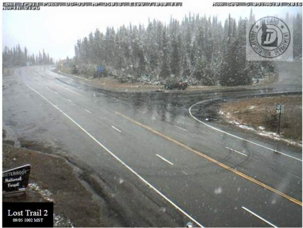
Yes, that is snow falling. A cold upper trough is bringing the winter-like weather there.
THE WEEKEND: We will introduce the risk of “widely scattered, mostly afternoon and evening showers and storms” Saturday and Sunday, but the overall chance of any one spot getting wet remains rather small. We project highs this weekend between 88 and 91 degrees with a partly sunny sky both days.
NEXT WEEK: The new run of the GFS model (12Z) continues the idea of relatively dry weather for Alabama next week. Perhaps a higher chance of rain toward the end of the week with an approaching front.
AT THE BEACH: Much better weather for the Alabama Gulf Coast (and the coast of Northwest Florida as well) for the rest of the week, with mostly sunny days, fair nights, and only isolated storms. Highs in the upper 80s on the immediate coast, with low 90s inland. See a very detailed Gulf Coast forecast here.
TROPICS: Hermine, now a “post tropical” storm, continues to bring dangerous surf and rip currents to the New England coast; winds have gusted to over 50 mph at Nantucket this morning. It will hang around for a few days before finally moving out to sea late this week.
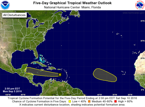
One wave moving the eastern Caribbean could show some slow development late this week, but it will most likely move into the Yucatan peninsula of Mexico before getting its act together. And, another wave in the eastern Atlantic could show some slow development in coming days, but it remains far from land.
WEATHER BRAINS: Don’t forget you can listen to our weekly 90 minute netcast anytime on the web, or on iTunes. This is the show all about weather featuring many familiar voices, including our meteorologists here at ABC 33/40.
CONNECT: You can find me on all of the major social networks…
Facebook
Twitter
Google Plus
Instagram
Look for the next Weather Xtreme video here by 7:00 a.m. tomorrow…



