


Here is a peek at the 00Z NAM, valid at 12:00 midnight local time Friday night. The thickness values are 1000-850 mb…
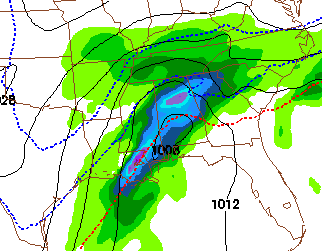
Still looks like a cold rain for much of Alabama, with ice potential for Tennessee and North Georgia. As colder air moves in after midnight, a wintry mix will be possible as far south as I-20. Thermal values are very tricky for this kind of system far in advance when dealing with shallow cold air, so this could change. A full discussion and new Weather Xtreme video will be posted by 7:00 a.m. tomorrow!



